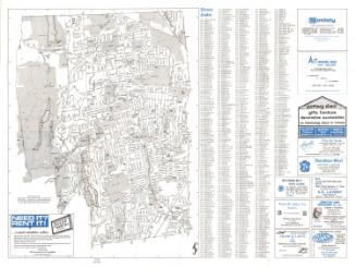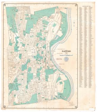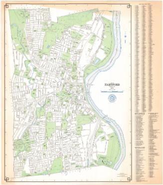
New Map of Hartford and West Hartford, Connecticut
PublisherPublished by
Price & Lee Co.
American
Dateabout 1954
MediumPhoto offset lithography; black printer's ink on wove paper
DimensionsPrimary Dimensions (front image (a) height x width): 20 1/8 x 24 7/8in. (51.1 x 63.2cm)
Primary Dimensions (back image (b) height x width): 23 3/4 x 22 1/8in. (60.3 x 56.2cm)
Sheet (height x width): 28 x 27in. (71.1 x 68.6cm)
Primary Dimensions (back image (b) height x width): 23 3/4 x 22 1/8in. (60.3 x 56.2cm)
Sheet (height x width): 28 x 27in. (71.1 x 68.6cm)
ClassificationsGraphics
Credit LineConnecticut Museum of Culture and History collection
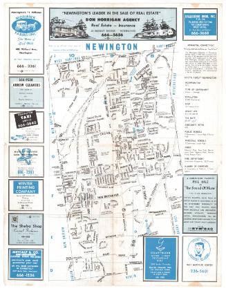
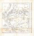
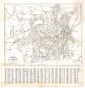
DescriptionTwo-sided map shows Hartford and West Hartford on the front (side a), and East Hartford on the back (side b). The map of Hartford and West Hartford extends to the town lines of Bloomfield and Windsor to the north, the Connecticut River and town line of East Hartford to the east, the town lines of Newington and Wethersfield to the south, and the town lines of Farmington and Avon to the west. The map of East Hartford extends from the town line of South Windsor to the north, the town line of Manchester to the east, the town line of Glastonbury to the south, and the Connecticut River and boundary of Hartford to the west.
Both maps have street indexes and show the local roads, bus and trolley routes, railroads, parks, hospitals, reservoirs and rivers.
Both maps have street indexes and show the local roads, bus and trolley routes, railroads, parks, hospitals, reservoirs and rivers.
Object number2012.312.218
InscribedRecto (side a), bottom left of image area, printed in black ink: "NEW MAP OF / HARTFORD / AND / WEST HARTFORD / CONN. / The Price & Lee Co., / 106 ANN ST. / HARTFORD, CONN. / 1653 MAIN ST. / SPRINGFIELD, MASS. / 248 MEADOW ST. / NEW HAVEN, CONN. / 850 BROAD ST. / NEWARK, N.J."Bottom left of image area, printed in black ink: "54 [inscribed within a circle] / SHOWING PASSABLE STREETS ONLY - PROPOSED STREETS ELIMINATED"
Bottom right of image area, printed in black ink: "COPYRIGHT BY THE PRICE & LEE CO. NEW HAVEN, CONN."
Bottom right, printed in black ink: "PHOTO OFFSET / By / R. A. WELCKE OFFSET CO., Inc. / New York City"
Verso (side b), bottom left, printed in black ink: "NEW MAP OF / EAST HARTFORD / CONN. / The Price & Lee Co., / PUBLISHERS / 106 ANN ST. / HARTFORD, CONN. / 1653 MAIN ST. / SPRINGFIELD, MASS. / 248 MEADOW S.T / NEW HAVEN, CONN. / 850 BROAD ST. / NEWARK, N.J. / COPYRIGHT BY THE PRICE & LEE CO. NEW HAVEN, CONN."
Bottom left, printed in black ink: "54 [inscribed within a circle] / SHOWING PASSABLE STREETS ONLY - PROPOSED STREETS ELIMINATED"NotesCartographic Note: Scale, front (a): 1 7/8 inches equals 3200 feet. Scale, back (b): About 3 1/2 inches equals 4000 feet
Subject Terms
- Hartford (Conn.)
- East Hartford (Conn.)
- West Hartford (Conn.)
- Streets
- Roads
- Connecticut River
- Park River (Hartford, Conn.)
- Rivers
- Reservoirs
- Elizabeth Park (Hartford, Conn.)
- Keney Park (Hartford, Conn.)
- Bushnell Park
- Goodwin Park
- Pope Park (Hartford, Conn.)
- Parks
- Street-railroads
- Railroads
- New York, New Haven and Hartford Rail Road Company
- Lithographs
- City and Town Maps
- Regional Maps
- Road Maps
- Map Cataloging Project
- Hartford
- West Hartford
- East Hartford
Collections
- Maps and Charts: Finding Your Place in Connecticut History
On View
Not on view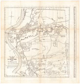
R. A. Welcke Offset Co.
probably 1967