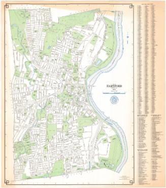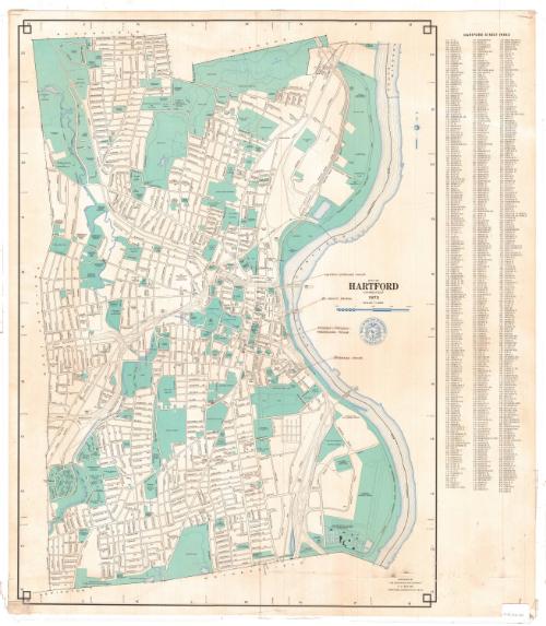
City of Hartford, Connecticut
MakerMade by
Metropolitan District Commission
American, founded 1929
Date1973
MediumScreen print; black, blue and turquoise printer's inks on wove paper
DimensionsPrimary Dimensions (image height x width): 32 1/8 x 23 1/8in. (81.6 x 58.7cm)
Sheet (height x width): 33 1/8 x 29 1/8in. (84.1 x 74cm)
Sheet (height x width): 33 1/8 x 29 1/8in. (84.1 x 74cm)
ClassificationsGraphics
Credit LineConnecticut Museum of Culture and History collection
DescriptionMap of Hartford, Connecticut, from the town lines of Bloomfield and Windsor to the north, the Connecticut River to the east, the town lines of Newington and Wethersfield to the south, and the town line of West Hartford to the west. Streets are labeled and public spaces, including parks, schools, colleges, municipal infrastructure and cemeteries are colored turquoise. Water sources (rivers, reservoirs, ponds and the like) are denoted with blue lines. To the right of the map is the street index.
Object number2012.312.167
InscribedRecto, right side, printed in black ink: "CITY OF / HARTFORD / CONNECTICUT / 1973"Right side, printed in blue ink: "[city seal] SEAL OF THE CITY OF HARTFORD / CONNECTICUT"
Right side, handwritten in brown ink: "WATSON-STEWARD HOUSE [with line pointing to hand-drawn box on map]"
Right side, handwritten in brown ink: "ST. JOHN'S CHURCH [with line pointing to hand-drawn box on map]"
Right side, handwritten in brown ink: "RICHARDS-SEHDLON- / WOODBRIDGE HOUSE [with line pointing to hand-drawn box on map]"
Right side, handwritten in brown ink: "BARNARD HOUSE [with line pointing to hand-drawn box on map]"
Bottom right, printed in black ink: "PREPARED BY / THE METROPOLITAN DISTRICT / P.O. BOX 800 / HARTFORD CONNECTICUT 06101"NotesCartographic Note: Scale: 1 inch equals 1000 feet
Subject Terms
- Hartford (Conn.)
- Connecticut River
- Park River (Hartford, Conn.)
- Rivers
- Reservoirs
- Goodwin Park (Hartford, Conn.)
- Bushnell Park (Hartford, Conn.)
- Trinity College (Hartford, Conn.)
- Pope Park (Hartford, Conn.)
- Elizabeth Park (Hartford, Conn.)
- Keney Park (Hartford, Conn.)
- Parks
- Screen Prints
- City and Town Maps
- Map Cataloging Project
- Hartford
Collections
- Maps and Charts: Finding Your Place in Connecticut History
On View
Not on view