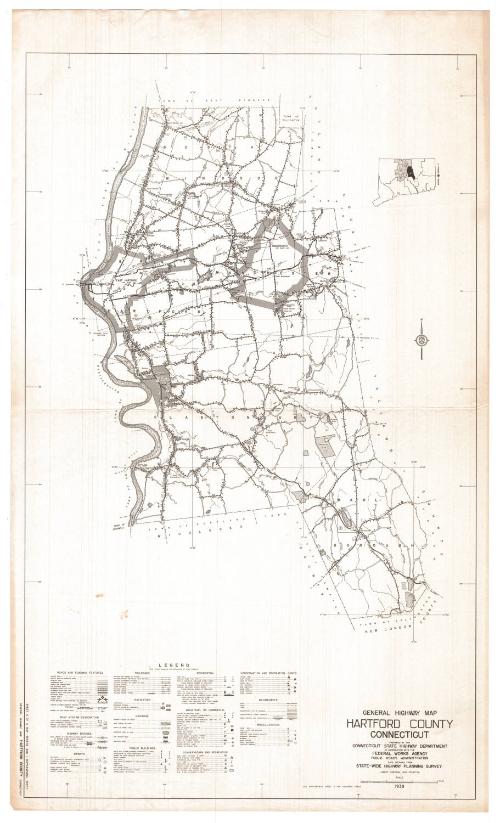
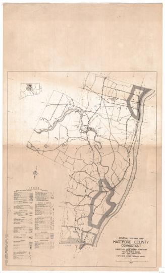
General Highway Map, Hartford County, Connecticut
PublisherPublished by
Connecticut State Highway Department
American, 1895 - 1969
PublisherPublished by
Federal Works Agency
American, 1939 - 1949
Date1938
MediumLithography; black printer's ink on paper
DimensionsPrimary Dimensions (image height x width): 28 7/8 x 17 5/8in. (73.3 x 44.8cm)
Sheet (height x width): 31 x 18 5/8in. (78.7 x 47.3cm)
Sheet (height x width): 31 x 18 5/8in. (78.7 x 47.3cm)
ClassificationsGraphics
Credit LineConnecticut Museum of Culture and History collection
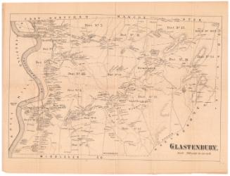
DescriptionMap of South Windsor, East Hartford, Manchester, Glastonbury and Marlborough, in Hartford County, Connecticut, from the town line of East Windsor, the Tolland county line to the east, the Middlesex and New London county lines to the south, and the Connecticut River to the west. Highways and roads of various surfaces are prominently featured, with bridges; airways; railroads; drainage systems (streams, rivers, marshes, reservoirs, lakes, etc.); public, private and industrial buildings; and conservation and recreation areas also depicted. The symbols and lines used to denote these features are explained on the legend, located to the left of the map.
Object number2012.312.157
InscribedRecto, bottom right corner, printed in black ink: "GENERAL HIGHWAY MAP / HARTFORD COUNTY / CONNECTICUT / PREPARED BY THE / CONNECTICUT STATE HIGHWAY DEPARTMENT / IN COOPERATION WITH THE / FEDERAL WORKS AGENCY / PUBLIC ROADS ADMINISTRATION / DATA OBTAINED FROM / STATE-WIDE HIGHWAY PLANNING SURVEY / LAMBERT CONFORMAL CONIC PROJECTION / 1938"Bottom right corner, printed in black ink: "SEE SUPPLEMENTAL SHEET A FOR ENLARGED AREAS"
Bottom left corner, printed in black ink: "SHEET 6 OF 6 MAP SHEETS AND 1 SUPPLEMENTAL SHEET / GENERAL HIGHWAY MAP HARTFORD COUNTY CONNECTICUT"NotesCartographic Note: Scale: 1 inch equals 1 mile
Collections
- Maps and Charts: Finding Your Place in Connecticut History
On View
Not on view

Connecticut State Highway Department
1916