Map of the United States of America with its Territories.including also a part of Upper and Lower Canada and Mexico.
PublisherPublished by
Reed & Barber
American, founded 1837
Date1842
MediumEngraving; black printer's ink and watercolor on wove paper mounted on fabric
DimensionsPrimary Dimensions (image height x width): 28 x 42 1/4in. (71.1 x 107.3cm)
Sheet (height x width): 30 5/8 x 45in. (77.8 x 114.3cm)
Sheet (height x width): 30 5/8 x 45in. (77.8 x 114.3cm)
ClassificationsGraphics
Credit LineMuseum purchase
DescriptionMap of the United States with part of Canada to the north, the Atlantic Ocean to the east, the Gulf of Mexico and part of Mexico to the south, and the Pacific Ocean to the west. The northern boundary of the western United States is shown at 49 degrees north latitude. Principle rivers, lakes, mountains, towns, and cities are shown. Elevation is indicated by hachure marks. Larger states are subdivided into counties. Names of Indian tribes inhabiting Indian Territory and other areas are indicated. Tables show distances between principle cities and towns and the population of the states according to the 1840 Census, divided into whites, "free colored," and slaves.
Object number1967.111.0
MarkingsOn verso, upper left, on gummed label, typed in black ink, "MAPS / Case 5 / No. 10"On verso, upper right, on gummed label, typed in black ink, "MAPS / Case 5 / NO. 10"InscribedOn recto, lower right, printed in black ink, "MAP / OF THE / UNITED STATES / OF / AMERICA / WITH ITS TERRITORIES & DISTRICTS / Including also a part of / UPPER & LOWER CANADA / AND MEXICO. / PUBLISHED BY REED & BARBER / Hartford. / 1842"
On recto, upper left, in black ink, "71930"
On verso, upper left, in pencil, "MAPS / Case 5 / NO. 10"; in black ink, "71930"
On verso, upper right, in pencil, "MAPS / Case 5 / NO. 10"
NotesCartographic Note: One and one half inches equals 100 miles
Collections
- Maps and Charts: Finding Your Place in Connecticut History
On View
Not on view

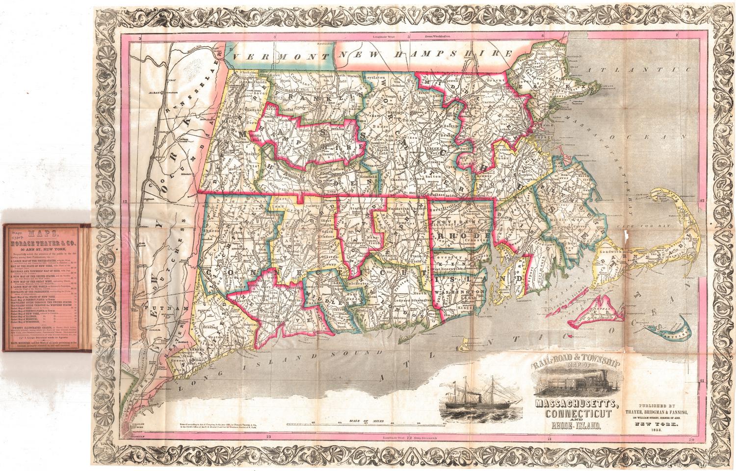
Thayer, Bridgman & Fanning
1853

H. F. Sumner & Co.
1833
