Hartford
PublisherPublished by the
Guyde Publishing Company
American, before 1890 - after 1945
Date1945
MediumLithography; black printer's ink on wove paper, in paper covers
DimensionsPrimary Dimensions (image height x width): 11 1/8 x 10 1/2in. (28.3 x 26.7cm)
Sheet (height x width): 17 1/4 x 11 1/4in. (43.8 x 28.6cm)
Sheet (height x width): 17 1/4 x 11 1/4in. (43.8 x 28.6cm)
ClassificationsGraphics
Credit LineGift of Mary B. Fenn
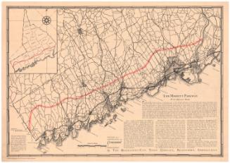
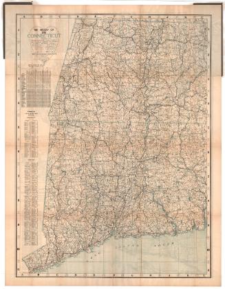
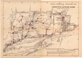
DescriptionPocket map with Hartford and West Hartford, Connecticut on one side and Connecticut on the other. The Hartford/West Hartford map shows local streets and parks. There is a street index at the bottom. The Connecticut map shows state, township and country roads. Towns are marked with black circles. Physical features depicted include lakes and elevation, conveyed with triangles that represent hills. There are two inset maps on the left side, one that depicts the New England states and show distances in miles between towns in the region, and the other that shows western Connecticut and eastern New York State. The maps are folded into a guide to Hartford-area bus transportation to points in Connecticut and New York City. The guide also contains advertisements and photographs of Connecticut tourist attractions.
Object number2000.183.1
InscribedFront cover, center, printed in black ink: "OCT 1945 GUIDE / HARTFORD / Street Map / Street Index / Buses / CONNECTICUT / Road Map / Towns / Trains"Hartford side of map, right side, printed in black ink: "HARTFORD / Copyright Jan. 1938 by / The Guyde Publ. Co."
Connecticut side of map, bottom right, printed in black ink: "CONNECTICUT / Copyright 1938 THE GUYDE PUBL. CO. Hartford, Conn."NotesCartographic Note: No scale
Collections
- Maps and Charts: Finding Your Place in Connecticut History
On View
Not on view
Blum's Commercial Map Publishing Company
1927-1928