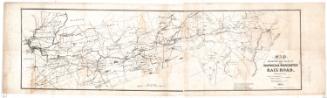
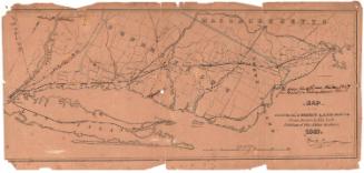
Map of the Shore Line Rail Road route Between New York and Boston, showing it's Rail Road and Steamboat Connection with New York, New Haven, New London, Stonington, Providence, Newport and Boston
PrintmakerEngraved by
H. F. Walling's Map Establishment
American, founded 1856
PrinterPrinted by
H. F. Walling's Map Establishment
American, founded 1856
PublisherPublished by
H. F. Walling's Map Establishment
American, founded 1856
Date1860
MediumLithography; black printer's ink and watercolor on wove paper mounted on fabric
DimensionsPrimary Dimensions (image height x width): 28 3/4 x 34 3/4in. (73 x 88.3cm)
Sheet (height x width): 31 x 38in. (78.7 x 96.5cm)
Sheet (height x width): 31 x 38in. (78.7 x 96.5cm)
ClassificationsGraphics
Credit LineConnecticut Museum of Culture and History collection
DescriptionDetailed map of southern New England states, including Connecticut, Rhode Island, and Massachusetts, wtih part of New York. Drainage, cities and towns, state boundaries, township lines, the railroad network, and steamboat connections are indicated. Elevation is not indicated.
Object number2012.312.287
MarkingsOn verso, upper right, on gummed label, typed in black ink, "Map of the Shore Line Rail Road Route / between New York and Boston, Showing / it's Rail Road and Steamboat connection / with New York, New Haven, New London, / Stonington, Providence, Newport and Boston. / H. F. Walling's Map Establishment. / New York, 1860 / 28 x 35"; in pencil, "Case 3 / No. 15"InscribedOn recto, lower center, printed in black ink, "MAP / OF THE / SHORE LINE RAIL ROAD / Route between New York and Boston, / Showing it's Rail Road and Steamboat connection with NEW YORK, NEW HAVEN, NEW LONDON, STONINGTON, / PROVIDENCE, NEWPORT AND BOSTON. / 1860."On recto, lower left, printed in black ink, "Engraved, Printed, Colored & Mounted at H. F. Walling's Map Establishment, 356, 358, 360 Pearl St. N. Y."
On recto, lower right, printed in black ink, "THE SHORE LINE possesses the ad-/ vantages over the interior lines to Boston of being free / from dust with cool and pleasant sea breezes / in summer, from the water, which it skirts all the way from New York to Providence, being equally / certain in its connections and its time of arri-/ val. / For passengers to NEWPORT, PROVIDENCE, NEW BEDFORD, TAUNTON and places on the CAPE / it is a direct reliable route of much shorter time / than any other. / Passengers leaving New York at 8 AM. arrive at Boston about 6 PM."
On verso, lower right, in pencil, "2012.312.287"NotesCartographic Note: No scale
Collections
- Maps and Charts: Finding Your Place in Connecticut History
On View
Not on view

Thayer, Bridgman & Fanning
1853