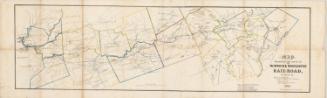
Map Exhibiting the route of the Norwich & Worcester Rail-Road
SurveyorSurveyed by
James Pugh Kirkwood
American, 1807 - 1877
SurveyorSurveyed by
William Lester Jr.
Date1835
MediumLithograph; black printer's ink on wove paper
DimensionsPrimary Dimensions (image height x width): 13 x 45in. (33 x 114.3cm)
Sheet (height x width): 15 x 51 3/4in. (38.1 x 131.4cm)
Sheet (height x width): 15 x 51 3/4in. (38.1 x 131.4cm)
ClassificationsGraphics
Credit LineConnecticut Museum of Culture and History collection
DescriptionMap of the Norwich and Worcester Railroad, from Norwich, Connecticut, to Worcester, Massachusetts, and the land surrounding it, oriented on the map so that north faces toward the top right corner. Each of the towns is outlined in what is probably watercolor, and features such as lakes, ponds, rivers, canals and local roads are depicted. Buildings are shown as small black squares. Quite a few cotton and wool factories are labeled along the Quinebaug River.
Object number2012.312.142
MarkingsRecto, bottom left and right corners, printed in black ink: "MAPS / Drawer / 68"InscribedRecto, bottom right, printed in black ink: "MAP / EXHIBITING THE ROUTE OF / THE / NORWICH & WORCESTER / RAIL-ROAD, / Surveyed by / James P. Kirkwood. / James Laurie. / Civil Engineers. / William Lester Jr. / Homer T. Bostwick. / Assistants. / 1835. / T. Moore's Lithography. Boston. (successor to Pendleton)"Bottom, printed in black ink: "Note. The Topography in the immediate / vicinity of the Route is from actual survey, / the rest is from Town & other maps. / Length of Road 59 Miles / Average inclination Pr Mile 11 feet. / Greatest inclination Pr Mile 20 feet."
Verso, left side, handwritten in pencil: "Box / #35"
Left side, handwritten in black ink: "Sydney Stanley / Tolland Conn"NotesCartographic Note: Scale: 1 inch equals 1 mile
Norwich was a major transportation center in the nineteenth century, providing a convenient route from Boston to New York via the Norwich & Worcester Railroad, which connected with Long Island Sound steamboats at the Thames River steamboat landing. Irish labor was extensively used to build the railroad, which was incorporated in 1835 and completed and opened for service in 1840. James Pugh Kirkwood, a young Scottish emigrant, was employed as a surveyor on the project. Kirkwood went on to an illustrious career, working on many other railroads and waterworks throughout the eastern United States. The Connecticut Historical Society has two copies of Kirkwood's map of the Norwich & Worcester Railroad, one uncolored and one colored.
Collections
- Maps and Charts: Finding Your Place in Connecticut History
On View
Not on view