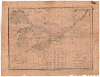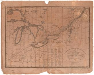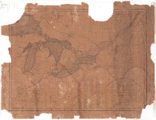
Map of Upper and Lower Canada and United States, contiguous
PrintmakerEngraved by
Thomas Kensett
American, 1786 - 1829
PrintmakerEngraved by
Amos Doolittle
American, 1754 - 1832
After a work byAfter a work by
Pierre Francois Tardieu
French, 1757 - 1822
Date1812
MediumEngraving; black printer's ink on wove paper
DimensionsPrimary Dimensions (image height x width): 13 9/16 x 18 5/16in. (34.4 x 46.5cm)
Sheet (height x width): 15 3/4 x 20 3/8in. (40 x 51.8cm)
Sheet (height x width): 15 3/4 x 20 3/8in. (40 x 51.8cm)
ClassificationsGraphics
Credit LineMuseum purchase
DescriptionMap of what was Upper and Lower Canada, from the wildnerness north of Lower Canada to the north, the border of the United States to the east, the Western Reserve of Connecticut to the south, and Lake Superior to the west. Settlements are shown in districts divided into numbered sections, which correspond to a list of townships that appears below the map. Lakes and rivers are labeled, and width in yards of some of the rivers is provided.
Object number1918.5.0
MarkingsOn verso, lower left, on gummed label, typed in black ink, "Canada, 1812 / Map of upper and / Lower Canada, Kensett / & Doolittle", typed in red ink, ""Map / Folio / #27", in pencil, "MAP BOX 3b"Lower right, on gummed label, in black ink, "Print / Drw 2 / #27", in pencil, "MAP / BOX / 2b"InscribedRecto, bottom right, printed in black ink: "TO THE OFFICERS OF THE ARMY AND THE CITIZENS OF THE UNITED STATES / This / Map / OF / UPPER AND LOWER CANADA / and United States, contiguous, Contracted from the Manuscript surveys of P.F. / Tardieu. / Is respectfully Inscribed by the public's / most Obedient Servant / THOMAS KENSETT"
Bottom, printed in black ink: "Copy-right secured and entered acording to Act of Congress November 4th 1812"
On verso, upper left, in red ink, "28320"NotesCartographic Note: No scale
Collections
- Maps and Charts: Finding Your Place in Connecticut History
On View
Not on view