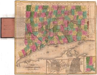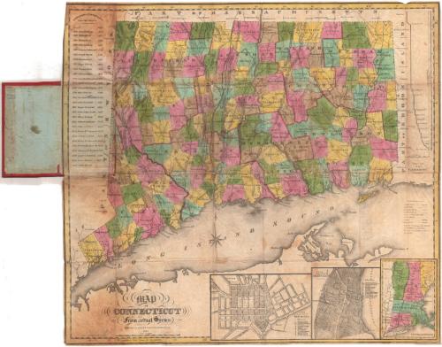
Map of Connecticut from actual Survey
PublisherPublished by
Brown and Parsons
American, 1838 - 1851
PrintmakerEngraved by
Daggett & Ely
American, 1831 - 1836
Date1847
MediumEngraving; black printer's ink and watercolor on wove paper, in cardboard covers
DimensionsPrimary Dimensions (image height x width): 19 x 21 1/8in. (48.3 x 53.7cm)
Sheet (height x width): 19 1/8 x 21 5/8in. (48.6 x 54.9cm)
Sheet (height x width): 19 1/8 x 21 5/8in. (48.6 x 54.9cm)
ClassificationsGraphics
Credit LineMuseum purchase
DescriptionPocket map of the state of Connecticut, with part of Massachusetts to the north, part of Rhode Island to the east, part of Long Island and the Long Island Sound to the south, and part of New York to the west. The state is divided into counties, which are outlined in red, and towns, which are colored green, blue, pink, yellow or brown. Physical features include elevation, conveyed with hachure marks, rivers, and ponds/lakes. To the left of the image is a list of the governors of the state from 1665 to 1847. To the right is a profile of the Farmington Canal. At the bottom are inset maps of New Haven, Hartford, and the New England states.
Object number1951.37.0
InscribedFront cover, gold tooled: "MAP OF / CONNECTICUT"Inside cover, top left, handwritten in red ink: "59665"
Top left, handwritten in pencil: "Maps / 59665"
Center, handwritten in pencil: "[illegible] / [illegible] / H.S. Simmons"
Recto, bottom left, printed in black inK: "MAP / OF / CONNECTICUT / From actual Survey / Published by BROWN & PARSONS, Hartford Conn. / 1847"
Bottom left, printed in black ink: "Engraved by Daggett & Ely New Haven."
Verso, left side, handwritten in pencil: [list of names]
Left side, handwritten in pencil: "A. C. Burbank"NotesCartographic Note: Scale: 1 inch equals almost 5 1/2 miles
Collections
- Maps and Charts: Finding Your Place in Connecticut History
On View
Not on view