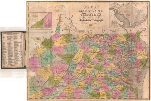
Map of Maryland, Virginia, and Delaware
PublisherPublished by
Brown and Parsons
American, 1838 - 1851
Date1838
MediumEngraving; black printer's ink and watercolor on wove paper, in cardboard covers
DimensionsPrimary Dimensions (image height x width): 14 x 17 1/4in. (35.6 x 43.8cm)
Sheet (height x width): 14 1/8 x 17 3/8in. (35.9 x 44.1cm)
Sheet (height x width): 14 1/8 x 17 3/8in. (35.9 x 44.1cm)
ClassificationsGraphics
Credit LineConnecticut Museum of Culture and History collection
DescriptionPocket map of the states of Maryland, Virginia and Delaware, with Pennsylvania to the north, the Atlantic Ocean to the east, and Ohio to the west. The states are divided into counties, colored blue, pink, green, yellow or lavender. Principal and local roads are shown, as is the Ohio and Chesapeake Canal, part of what is probably the James River and Kanawha Canal, and the Junction Canal. The Ohio Railroad and an unnamed proposed railroad between Washington, D.C. and Hartford, Maryland, are also depicted. Physical features shown include elevation, conveyed with hachure marks; rivers, and lakes. In the top left is an inset map of the southwest part of Virginia, and in the top right is an inset map of Washington, D.C. and Georgetown. On the inside cover is a population table for the counties in each state.
Object number1984.141.0
MarkingsVerso, top right, stamped in blue ink: "THE CONNECTICUT / 84096 / HISTORICAL SOCIETY"Right center, stamped in blue ink: "THE CONNECTICUT / 84096 / HISTORICAL SOCIETY"InscribedFront cover, gold tooled: "DELAWARE / MARYLAND / & VIRGINIA"
Inside cover, top, printed in black ink: "POPULATION OF THE COUNTIES IN MARYLAND, / VIRGINIA AND DELAWARE."
Recto, top, printed in black ink: "MAP OF / MARYLAND, / VIRGINIA / AND / DELAWARE. / Published by BROWN & PARSONS Hartford Ct / 1838."NotesCartographic Note: Scale: 1 inch equals about 25 miles
Collections
- Maps and Charts: Finding Your Place in Connecticut History
On View
Not on view
Samuel Augustus Mitchell
1835
Samuel Augustus Mitchell
1834