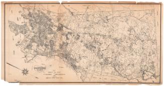
Map Showing Plan of Proposed Pipeline Connecting Reservoir No. 4 with the Distributing System
SurveyorSurveyed by
William E. Johnson
American, 1867 - 1937
SurveyorSurveyed by
James F. Shaughnessy
American, 1876 - 1934
Date1901
MediumDrawing; black, red, and blue ink on wove paper on fabric
DimensionsPrimary Dimensions (image height x width): 30 x 86in. (76.2 x 218.4cm)
Sheet (height x width): 33 1/8 x 88 1/2in. (84.1 x 224.8cm)
Sheet (height x width): 33 1/8 x 88 1/2in. (84.1 x 224.8cm)
ClassificationsGraphics
Credit LineConnecticut Museum of Culture and History collection
DescriptionMap of property between Reservoir No. 1 and Reservoir No. 4 in West Hartford, Connecticut. A canal connects Reservoir 1 with Long's Pond. A proposed pipeline runs from Long's Pond to Reservoir 4 though or near property belonging to Robert Price, Henry Selden, S. C. Colt, A Holt, P. E. Stanley, W. Woodruff, Anderson, Hansen, and Burt. Also shown are Colt's Pond and Hansen's Pond, property belonging to the City of Hartford, and watershed with acreage indicated. Roads include the New Britain and Farmington Road, Middle Road, and South Road.
Object number1970.27.33
MarkingsOn verso, lower left, stamped in blue ink, "CtHi"Upper left, stamped in blue ink, "CtHi" "CtHi"InscribedOn recto, upper left, in black ink, "MAP SHOWING / PLAN OF / PROPOSED PIPELINE / CONNECTING RESERVOIR NO 4 WITH / THE DISTRIBUTING SYSTEM / HARTFORD WATER WORKS / SCALE 1 INCH = 200 FEET FEB. 1901 / W. E. JOHNSON ENG. J. F. SHAUGHNESSY ASST."
On verso, lower left, in black ink, "acc 088145" "1970-27-33"
Upper left, in black ink, "1970-27-33" "0088145"NotesCartographic Note: One inch equals 200 feet
Collections
- Maps and Charts: Finding Your Place in Connecticut History
On View
Not on view