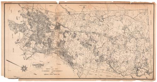
Map of Town and City of Stamford, Connecticut
PublisherPublished by
Dolph & Stewart
American, 1931 - 1939
SurveyorBased on an aerial survey by
W. L. Britton
American, active 1936
Date1936
MediumLithography; black printer's ink on wove paper
DimensionsPrimary Dimensions (image height x width): 21 x 41 3/8in. (53.3 x 105.1cm)
Sheet (height x width): 21 7/8 x 42 3/4in. (55.6 x 108.6cm)
Sheet (height x width): 21 7/8 x 42 3/4in. (55.6 x 108.6cm)
ClassificationsGraphics
Credit LineConnecticut Museum of Culture and History collection
DescriptionMap of the town and city of Stamford, Connecticut, oriented on the map with north pointing toward the bottom right corner, so that the Long Island Sound appears on the left side and Greenwich appears at the top. Local streets and land plots are depicted, some labeled with the owner's name and acreage. Parks, country clubs, cemeteries, rivers, reservoirs and ponds are labeled. The New York, New Haven and Hartford Railroad runs through Stamford from Greenwich.
Object number2012.312.127
InscribedRecto, bottom left, printed in black ink: "DOLPH & STEWART / MAP PUBLISHERS / 152 West 42nd Street / NEW YORK CITY"Bottom left, printed in black ink: "MAP / OF / TOWN AND CITY / OF / STAMFORD / CONNECTICUT / 1936"
Bottom left, printed in black ink: "REFERENCE / AERIAL SURVEY AND DEEDS / W.L. BRITTON"NotesCartographic Note: 1 inch equals 800 feet
Collections
- Maps and Charts: Finding Your Place in Connecticut History
On View
Not on view