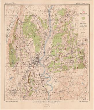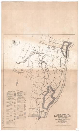
Map of Stamford Area, Connecticut
SurveyorGeology, ground-water conditions, and forest boundaries by
Arthur J. Ellis
American, died 1921
After a work byAfter a work by
United States Geological Survey
American, founded 1879
PrinterPrinted by
A. Hoen & Company
American, founded 1848
PublisherPublished by
United States Geological Survey
American, founded 1879
Date1915
MediumLithography; black and colored printer's inks on wove paper
DimensionsPrimary Dimensions (image height x width): 13 3/8 x 13 7/8in. (34 x 35.2cm)
Sheet (height x width): 15 7/8 x 17 1/8in. (40.3 x 43.5cm)
Sheet (height x width): 15 7/8 x 17 1/8in. (40.3 x 43.5cm)
ClassificationsGraphics
Credit LineConnecticut Museum of Culture and History collection
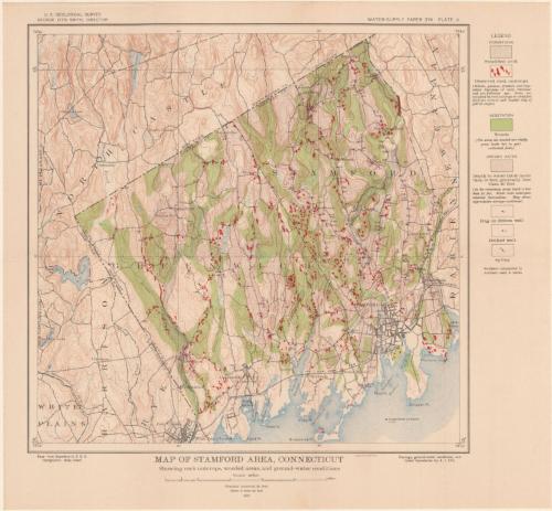
DescriptionMap of Stamford and Greenwich, Connecticut, and the surrounding area, from North Castle to the north, Darien and New Canaan to the east, the Long Island Sound to the south, and White Plains, New York to the west. Colors, lines and symbols are used to denote stratified drift, rock outcroppings, elevation, woods, ground water, dug or driven wells, drilled wells, and springs. There are numbers next to the wells and springs that correspond to numbers used in tables (not provided). Blue is used to denote water, including rivers, reservoirs, lakes and ponds. City streets are shown, with black squares and dots probably representing buildings. The New York, New Haven and Hartford Railroad runs along the coast.
Object number2004.157.2
InscribedRecto, top left, printed in black ink: "U.S. GEOLOGICAL SURVEY / GEORGE OTIS SMITH, DIRECTOR"Top right, printed in black ink: "WATER-SUPPLY PAPER 274 PLATE X"
Bottom left, printed in black ink: "Base from Stamford U.S.G.S. / topographic atlas sheets"
Bottom center, printed in black ink: "MAP OF HARTFORD AREA, CONNECTICUT / Showing rock outcrops, wooded areas, and ground-water conditions / Scale 1/62,5000 / Contour interval 20 feet / Datum is mean sea level / 1915"
Bottom right, printed in red ink: "A. HOEN & CO. BALTIMORE"
Bottom right, printed in black ink: "Geology, ground-water conditions, and / forest boundaries by A.J. Ellis"
Verso, top right, handwritten in pencil: "MAPS / Shelf / 98637 / Plate 10"
NotesCartographic Note: Scale: 1:62,500
On View
Not on view