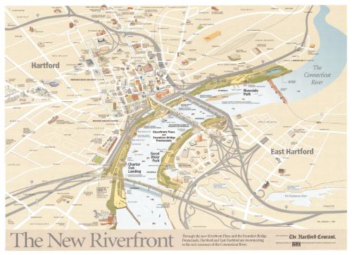
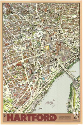
The New Riverfront
DraftsmanDrawn by
Philip Lohman
American, born 1939
PublisherPublished by
The Hartford Courant
American, founded 1764
Date1999
MediumLithography; colored printer's inks on wove paper
DimensionsPrimary Dimensions (image height x width): 21 x 28 3/4in. (53.3 x 73cm)
Sheet (height x width): 22 x 30in. (55.9 x 76.2cm)
Sheet (height x width): 22 x 30in. (55.9 x 76.2cm)
ClassificationsGraphics
Credit LineGift of Phil Lohman
DescriptionMap of Hartford and East Hartford, Connecticut focusing on the parks and walks along the Connecticut River. These include Riverwalk, Charter Oak Landing, Riverfront Plaza, Founders Bridge Promenade, and Riverside Park in Hartford, and Great River Park and the Hockanum River Linear Trail and Bikeway in East Hartford. Some portions of the Riverwalk are shown as "designed" but "awaiting funding." A "proposed circuit line route" is also shown. Adriaen's Landing is "proposed" but not yet designed or executed. Bridges and highways with exit and entrance ramps surround the green space along the river. Hartford neighborhoods are identified by name: "South Green" "Frog Hollow," etc.
Object number2001.193.0
MarkingsOn verso, lower center, stamped in black ink, "The Connecticut Historical Society / Library"; in pencil, "96944"InscribedOn recto, lower left, printed in gray ink, "The New Riverfront"Lower center, printed in black ink, "Through the new Riverfront Plaza and the Founders Bridge / Promenade, Hartford and East Hartord are reconnecting to the rich resources of the Connecticut River."
On verso, lower right, in pencil, "2001.193.0"NotesCartographic Note: No scale
Collections
- Maps and Charts: Finding Your Place in Connecticut History
On View
Not on view


Metropolitan District Commission
1972