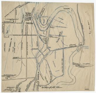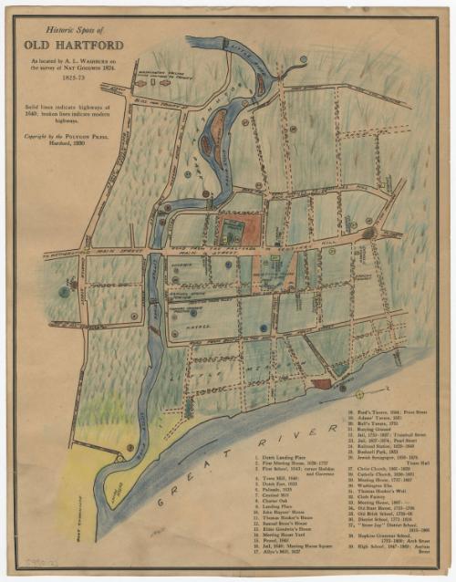
Historic Spots of Old Hartford
DraftsmanDrawn by
Albert L. Washburn
American, 1857 - 1948
After a work byAfter a work by
Nathaniel Goodwin
American, 1782 - 1855
PublisherPublished by
Polygon Press
American, founded 1926
Date1930
MediumLithography; black printer's ink and crayon on wove paper
DimensionsPrimary Dimensions (image height x width): 13 3/4 x 10 1/2in. (34.9 x 26.7cm)
Sheet (height x width): 14 x 11in. (35.6 x 27.9cm)
Sheet (height x width): 14 x 11in. (35.6 x 27.9cm)
ClassificationsGraphics
Credit LineConnecticut Museum of Culture and History collection
DescriptionEast-west oriented map of Hartford, Connecticut, as it appeared between the seventeenth and nineteenth centuries. Roads as they existed in 1640 are depicted with solid black lines, and "modern" roads in broken solid black lines. All of the roads are labeled and many of the modern roads are dated. Circled numbers on the map correspond to a reference list below it which names the site--dwellings, jails, meeting houses, forts, schools, and the like--and in some cases provides a date. Washington College (later renamed Trinity College) is depicted at the top of the map. The Connecticut River (Great River) and the Park River (Little River) are the only natural features depicted.
Object number2005.190.0
InscribedRecto, top left, printed in black ink: "Historic Spots of / OLD HARTFORD / As located by A.L. WASHBURN on / the survey of NAT GOODWIN 1824. / 1825-73 / Solid lines indicate highlways of / 1640; broken lines indicate modern / highways. / Copyright by the POLYGON PRESS, / HARTFORD, 1930"Bottom left corner, handwritten in pencil: "[99012]"NotesCartographic Note: No scale
Collections
- Maps and Charts: Finding Your Place in Connecticut History
On View
Not on view