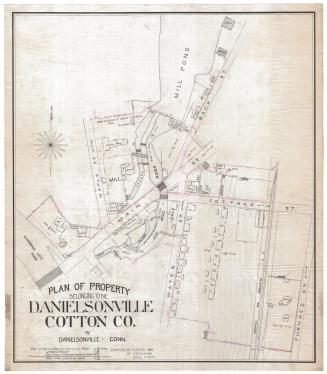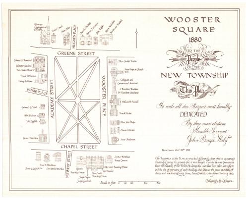
Wooster Square 1880
DraftsmanDrawn by
John B. Kirby Jr.
American
After a work byAfter a work by
Amos Doolittle
American, 1754 - 1832
Date1978
MediumLithography; brown ink on paper
DimensionsPrimary Dimensions (image height x width): 15 x 19in. (38.1 x 48.3cm)
Sheet (height x width): 16 x 20in. (40.6 x 50.8cm)
Sheet (height x width): 16 x 20in. (40.6 x 50.8cm)
ClassificationsGraphics
Credit LineGift of John B. Kirby, Jr.
DescriptionMap of Wooster Square in New Haven, Connecticut, from Hughes Place to the north, Wooster Place to the east, Brewery Street to the south, and Home Place to the west. The facades of the buildings around the square are faithfully recreated in ink, down to their correct proportions and numbers of windows and doors. They are labeled with the name of the building or the owner's name.
Object number1979.97.0
MarkingsVerso, top left, stamped in blue ink: "THE CONNECTICUT / 79123 / HISTORICAL SOCIETY"Top left, stamped in blue ink: "CtHi"InscribedRecto, right side, printed in brown ink: "WOOSTER SQUARE / 1880 / TO THE / People / OF THE / NEW TOWNSHIP / This Plan / Is with all due Respect most humbly / DEDICATED / By their most obedient / Humble Servant / John Burgis Kirby Junr / New Haven Octr. 28th 1978 / The BUILDINGS in this PLAN are marked differently from what is customary. / Instead of giving the ground plot, it was thought it would be more pleasing to / have the elevation of the Front. In doing this care has been taken, not only to / exhibit the proportions of each building, but likewise the exact number of / doors and windows.--Quoted from Amos Doolittle's MAP of NEW HAVEN of 1812 / Calligraphy by La Regina"
Verso, bottom left corner, handwritten in pencil: "Map Box / 124"NotesCartographic Note: Scale: About 9/16 inch equals 50 feet
Collections
- Maps and Charts: Finding Your Place in Connecticut History
On View
Not on view

William G. Dudley
1916-1927