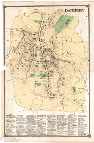
Map of Danbury Connecticut
SurveyorSurveyed by
E. C. Smith
American
SurveyorSurveyed by
Edward Van Zandt
American, born 1804
DraftsmanVignettes drawn by
George Hayward
Anglo-American, 1800 - 1872
PrintmakerLithographed by
George Hayward
Anglo-American, 1800 - 1872
PublisherPublished by
E. C. Smith
American
PublisherPublished by
Edward Van Zandt
American, born 1804
Dateprobably 1858
MediumLithography; printer's ink and watercolor on wove paper mounted on fabric
DimensionsPrimary Dimensions (image height x width): 49 1/2 x 40in. (125.7 x 101.6cm)
Sheet (height x width): 52 x 42 3/4in. (132.1 x 108.6cm)
Sheet (height x width): 52 x 42 3/4in. (132.1 x 108.6cm)
ClassificationsGraphics
Credit LineConnecticut Museum of Culture and History collection
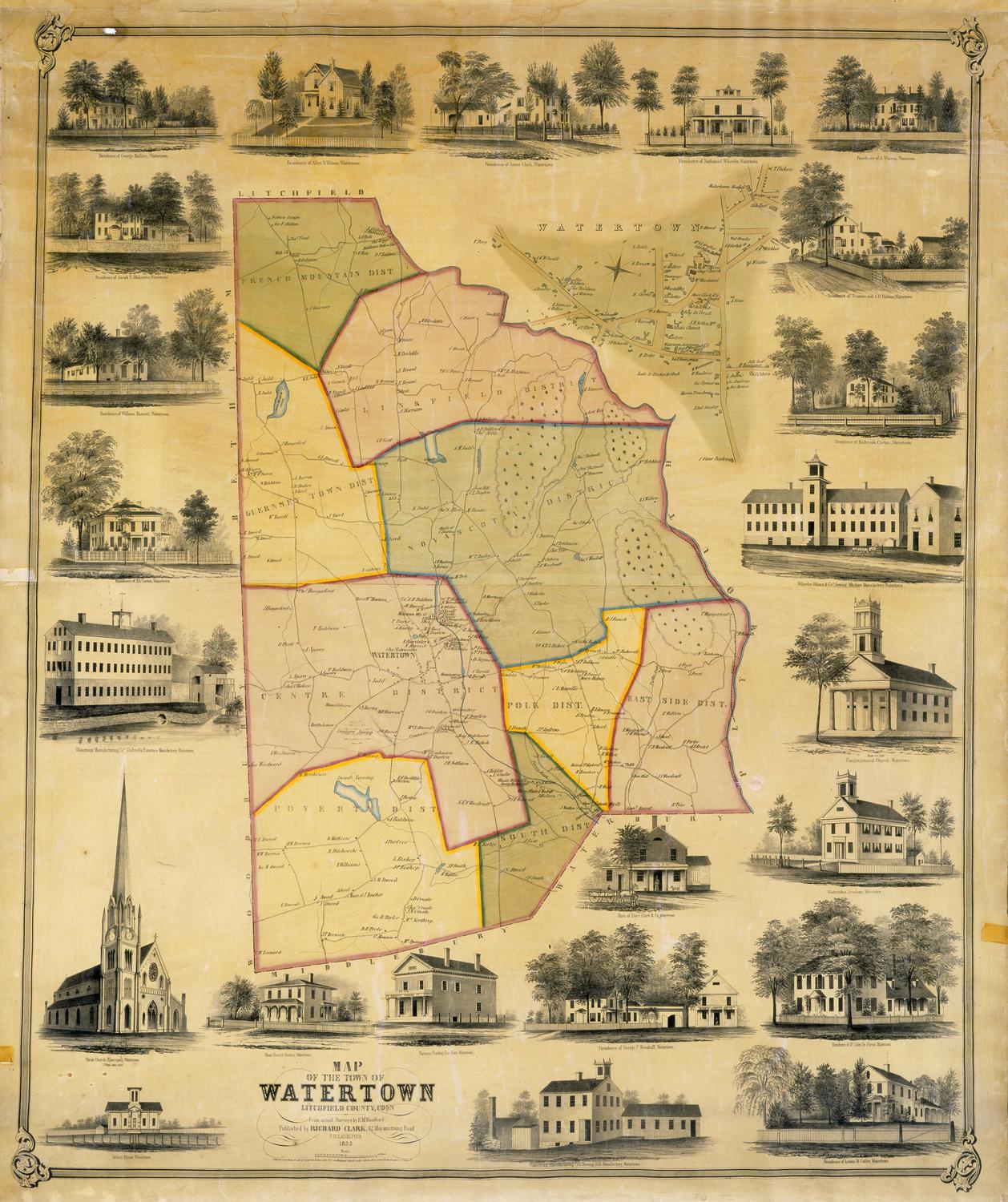
DescriptionMap of Danbury, Connecticut. The central area, probably representing the borough of Danbury, is surrounded by a red line. All streets are named and footprints of buildings are shown with names of property owners. Rivers and ponds are colored blue but are not named. Parks and cemeteries are colored green. The Danbury & Norwalk Railroad terminates in the town. The map is surrounded by nine large vignettes depicting Danbury from Hayes Hill; Sturdevant's Wool Hat Factory; Tweedy, White & Co. Fur Hat Manufactory; the residence of A. E. Tweedy; E.S. Davis Paper Box Manufactory; the Methodist Church and parsonage; Tweedy Brothers Fur Hat Manufactory; the new Congregational Church; and Wooster House."
Object number2012.312.301
MarkingsOn verso, upper left, on gummed label, typed in black ink, "MAPS / Case 5 / No. 11"On verso, upper right, on gummed label, typed in black ink, "MAPS / Case 5 / No. 11"InscribedOn recto, middle right, "Map / of / Danbury / CONNECTICUT / Surveyed and Published by / E.C. Smith & E. Van Zandt, / New York / Lith by Geo. Hayward, 120 Water St. N.Y. / Scale 200 feet to an inch."
On recto, bottom left, "1. Court House. / 2. Jackson's School. / 3. Roman Catholic Church. / 4. Gas Works. / 5. Pahquioque House. / 6. Universalist Church. / 7. Crofit, Bates & Wildman, _Fur Hat Factory. / 8. Rev. J. Jr. Townsend's School. / 9. Baptist Church. / 10. Methodist Church. / 11. Church of the Disciples. / 12. Old Congr. Church. / *Cosby, Hoyt & Co. Wool Hat Factory. "
On recto, bottom center, "DANBURY, CT / taken from Hayes' Hill"
On recto, bottom center right, "13. Episcopal Church. / 14. Starr & Barnum, Carpenter Shop. / 15. New Cong.l Church. / 16. Benedict & Montgomery. Wool Hat Factory. / 17. Rail Road Depot. / 18. Stevens, Ives, & Co. Planing and Sawing Mill. / 19. Wooster House. / 20. George Starr's._Box Factory. / 21. Tweedy, White & Co.Fur Hat Factory. / 22. Tweedy Brothers Fur Hat Factory. / 23. Tweedy, White & Co. Hat Forming Factory. / 24. E.A. Mallory, Fur Hat Factory. / 25. Hurlbut & Co. Fur Factory."
On verso, upper left, in pencil, "MAPS / Case 5 / No. 11"
On verso, upper right, in pencil, "MAPS / Case 5 / No. 11"
On verso, lower right, in pencil, "2012.312.301"
NotesCartographic Note: One inch equals 200 feet
Date Note: George Hayward view of Danbury from Hayes Hill was published by Smith and van Zandt about 1858. The map probably dates from about the same time.
Collections
- Maps and Charts: Finding Your Place in Connecticut History
On View
Not on view