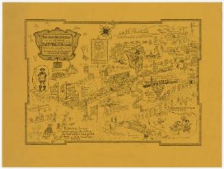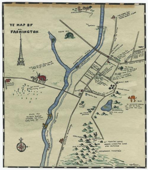
Ye Map of Farmington
DraftsmanDrawn by
Lydia B. Hewes
American, 1899 - 1986
Date1926
MediumDrawing; watercolor and ink on wove paper
DimensionsPrimary Dimensions (image height x width): 12 1/8 x 10 1/2in. (30.8 x 26.7cm)
Sheet (height x width): 12 1/8 x 10 1/2in. (30.8 x 26.7cm)
Sheet (height x width): 12 1/8 x 10 1/2in. (30.8 x 26.7cm)
ClassificationsGraphics
Credit LineConnecticut Museum of Culture and History collection
DescriptionManuscript map of Farmington, Connecticut, depicting the Farmington and Pequabuck Rivers and the Farmington Canal, the town and its public buildings, and the surrounding area. The railroad station and mail coach road are shown on the left, along with the old Indian burying ground and Round Hill. Below the town is a cluster of mountain peaks, including Rattlesnake Mountain and "Hospital Rock," "where smallpox once was isolated." On the right is an area where "ye mastodon grazed and left his bones 1000 years and more ago." Avon College appears at the very top of the map. Most of the drawings have labels identifying them.
Object number2005.189.0
MarkingsVerso, center, stamped in blue ink: "CtHi"Center, stamped in blue ink: "CtHi"InscribedRecto, top left, handwritten in black ink: "YE MAP OF / FARMINGTON"
Bottom right, handwritten in black ink: "L[?]B. Ye[illegible]es / Fecit 1926"
Verso, top left, handwritten in pencil: "[98981]"NotesCartographic Note: No scale
Collections
- Maps and Charts: Finding Your Place in Connecticut History
On View
Not on view