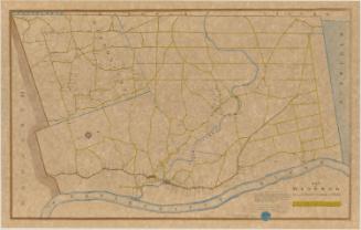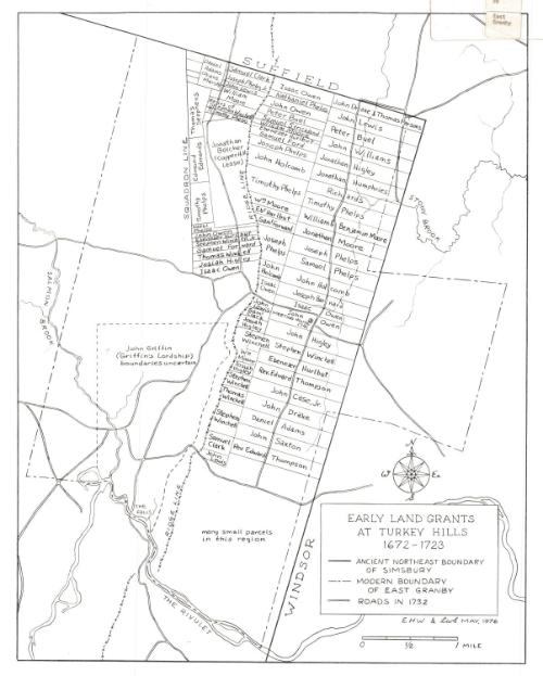
Early Land Grants at Turkey Hills, 1672-1723
DraftsmanDrawn by
Lester W. Smith
American, born 1927
DraftsmanDrawn by
Ethel H. Wilson
American, 1909 - 2000
Date1976
MediumLithography; black printer's ink on wove paper
DimensionsPrimary Dimensions (image height x width): 18 x 14 1/8in. (45.7 x 35.9cm)
Sheet (height x width): 19 1/2 x 15 1/2in. (49.5 x 39.4cm)
Sheet (height x width): 19 1/2 x 15 1/2in. (49.5 x 39.4cm)
ClassificationsGraphics
Credit LineGift of Mrs. G.W. Wilson
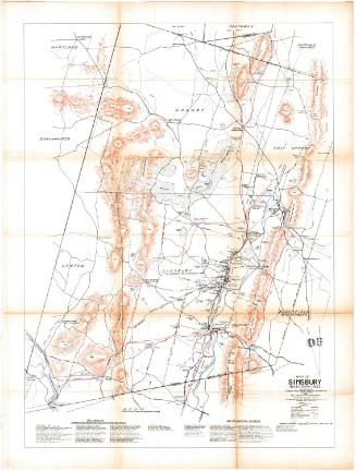
DescriptionMap of Turkey Hills in what was Simsbury and is now East Granby, Connecticut, with Suffield to the north, Windsor to the east, John Griffin's land to the south, and Salmon Brook to the west. The land grants are divided with solid lines and contain the owner's name. The old boundary of Simsbury and the modern boundary of East Granby are both shown, as are roads in 1732. Natural features depicted include the Metacomet Ridge ridgeline, Salmon Brook, Stony Brook, and a waterfall.
Object number1976.130.0
MarkingsRecto, top left corner, handwritten in pencil on sticker: "1976"Top left corner, printed in black ink on sticker: "MAPS / Box / 277"
Top right corner, printed in black ink on sticker: "Print / Drawer / 2B"
Top right corner, printed in black ink on sticker: "East / Granby"
Bottom left corner, printed in black ink on sticker: "MAPS / Box / 277"
Verso, printed in black ink on paper taped to map: "EARLY LAND GRANTS / AT TURKEY HILLS / 1672-1723 / Research by Ethel Wilson, East Granby / Cartography by Lester Smith, Suffield / The inspiration for this map of the early land grants in what is now East Granby came from "Historical Sketch of Turkey Hills and East Granby, Connecticut," by Albert Carlos Bates, read in 1945 before the Turkey Hills Study Club, of which Mrs. Wilson is a member. Research was done over a period of 4 1/2 years; the map was completed in May, 1976.
Town meeting, probate and other land records were studied in Simsbury and Windsor, and General Court and Colonial records in the archives of the Connecticut State Library were carefully reviewed. Many family genealogies, bibles, and letters were consulted, including material from the Springfield Hall of Records, the New England Genealogical Society, the Connecticut Historical Society, and the Connecticut State Library. Whenever possible, the land grants were traced to the present day.
The land grant descriptions were drawn and assembled in 2000 foot-to-the-inch scale and laid out on the U.S. Geological Survey map of East Granby. U.S. Department of Agriculture aerial photographs revealed useful recent evidence of many of the early lot lines.
An old fragmented map, found at Newgate Prison when the prison was taken over by the State of Connecticut, was of great help in detailing the third grant of land in 1723, west of the mountain.
Roads in Turkey Hills were taken from a map of ancient Simsbury drawn in 1732 by Samuel Higley. Land records researched by Mrs. Henry M. Clark of Suffield supplied information on roads leading into that town.
The compass rose and general cartographic style were taken from local maps darwn in the 1790's by Joab Griswold, County Surveyor.
July 22, 1976"InscribedRecto, top left corner, handwritten in pencil: "76789"
Bottom right, printed in black ink: "EARLY LAND GRANTS / AT TURKEY HILLS / 1672-1723"
Bottom right, printed in black ink: "EHW & LwS MAY, 1976"NotesCartographic Note: Scale: 2 5/8 inches equals 1 mile
Collections
- Maps and Charts: Finding Your Place in Connecticut History
On View
Not on view