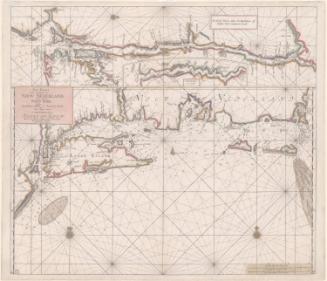
General Chart of the Coast from Gay Head to Cape Henlopen
SurveyorSurveyed by
Alexander Dallas Bache
American, 1806 - 1867
SurveyorSurveyed by
Ferdinand Rudolph Hassler
American, 1770 - 1843
PrintmakerElectrotyped by
George Mathiot
American, died 1873
PublisherPublished by
United States Coast Survey
American, founded 1807
Date1852
MediumElectrotype; black printer's ink on wove paper, lined with paper
DimensionsPrimary Dimensions (image height x width): 31 x 37 7/8in. (78.7 x 96.2cm)
Platemark (height x width): 33 3/4 x 41 3/8in. (85.7 x 105.1cm)
Sheet (height x width): 35 x 43in. (88.9 x 109.2cm)
Mount (height x width): 35 x 43in. (88.9 x 109.2cm)
Platemark (height x width): 33 3/4 x 41 3/8in. (85.7 x 105.1cm)
Sheet (height x width): 35 x 43in. (88.9 x 109.2cm)
Mount (height x width): 35 x 43in. (88.9 x 109.2cm)
ClassificationsGraphics
Credit LineConnecticut Museum of Culture and History collection
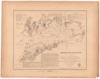
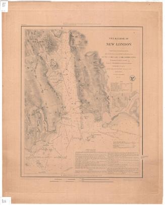
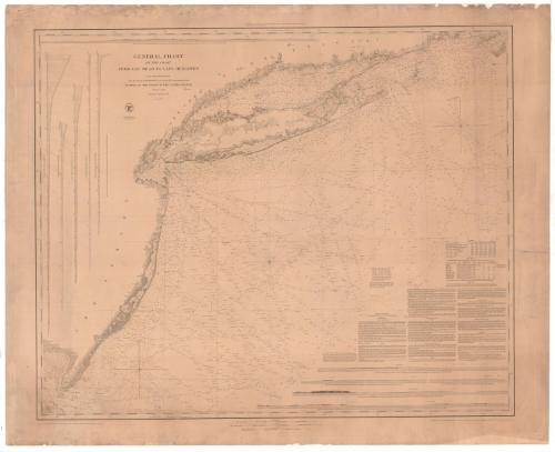
DescriptionChart of the coastlines of Delaware Bay, New Jersey, New York State and Long Island, and Connecticut, with Martha's Vineyard in the top right corner. The chart focuses on water depth in fathoms and ocean floor conditions, providing information about whether the ocean floor was sand, mud, ooze, clay, pebbles, and more, what color it was and its texture. Below the chart are several paragraphs of information containing sailing directions and two tables about tides and lighthouses. At the bottom of the sheet there are five views of the coastline, showing Block Island Sound, Navesink Highlands, Barnegat, the Delaware Bay with the Cape May lighthouse, and the Delaware Bay with the Cape Henlopen lighthouse. At the top left is a sixth view that shows the area south of Speonk, Long Island. On the left side of the sheet there are five charts showing water depth as it changes between two points.
Object number2012.312.221
InscribedRecto, top center, printed in black ink: "Presented to ____ / under authority of an Act of the Congress of the United States of June 3d, 1844, & by direction of the Treasury Department, / A.D. Bache Superintendent Coast Survey"Top right, printed in black ink: "Electrotype Copy No. 1 by G. Mathiot U.S.C.S."
Top left, printed in black ink: "GENERAL CHART / OF THE COAST / FROM GAY HEAD TO CAPE HENLOPEN / From a Trigonometrical Survey / under the direction of F.R. HASSLER and A.D. BACHE, Superintendents of the / SURVEY OF THE COAST OF THE UNITED STATES / Published in 1852 / A.D. Bache Superintendent / Scale 1/400,000"
Top left, printed in black ink: "[seal of the U.S. COAST SURVEY OFFICE] / Verified by L.L. Stevens / Lieut. U.S. Engrs. & Bvt. Major / Asst. in charge of office"
Bottom left, printed in black ink: "Reduction for Engraving by J. Farley Asst., W.M.C. Fairfax Asst., C. Mahon, J.J. Ricketss & J. Lambert Draughtsmen. Views by J. Farley Asst."
Bottom right, printed in black ink: "Topography engraved by F. Dankworth & O.A. Lawson. Lettering by John Knight. Views by O.A. Lawson. Soundings by J. Knight & W. Smith. Sections by G. McCoy & O.A. Lawson"NotesCartographic Note: Scale: 1:400,000
Constituent Note: Ferdinand Rudolph Hassler and Alexander Dallas Bache employed a large number of assistants on this map. Bache succeeded Hassler as Superintendant of the United States Coast Survey.
Medium Note: In 1851, George Mathiot developed an electrotyping process which greatly increased the effiency and speed of map printing. This 1852 map is one of the first maps produced using this new process, which would prove of great importance in producing maps for military use during the Civil War.
Collections
- Maps and Charts: Finding Your Place in Connecticut History
On View
Not on view