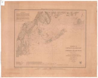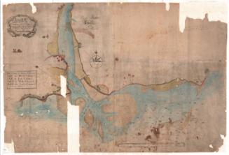
Harbors of Sheffield Island and Cawkins Island
PublisherPublished by
United States Coast Survey
American, founded 1807
SurveyorUnder the direction of
Ferdinand Rudolph Hassler
American, 1770 - 1843
SurveyorUnder the direction of
Alexander Dallas Bache
American, 1806 - 1867
SurveyorTriangulation by
Edmund Blunt
American, 1799 - 1866
SurveyorTopography by
Constant M. Eakin
French-American, 1794 - 1870
SurveyorHydrography by
George S. Blake
American, 1802 - 1871
PrintmakerEngraved by
S. T. Pettit
Date1848
MediumEngraving; printer's ink on wove paper
DimensionsPrimary Dimensions (image height x width): 14 x 17 1/4in. (35.6 x 43.8cm)
Platemark (height x width): 17 3/4 x 20 3/4in. (45.1 x 52.7cm)
Sheet (height x width): 18 1/2 x 23 1/8in. (47 x 58.7cm)
Platemark (height x width): 17 3/4 x 20 3/4in. (45.1 x 52.7cm)
Sheet (height x width): 18 1/2 x 23 1/8in. (47 x 58.7cm)
ClassificationsGraphics
Credit LineGift of the Charleston Library Society
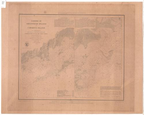
DescriptionTwo separate charts, side by side, of the coast of Norwalk, Connecticut, and the harbors of Sheffield Island and Cawkins Island. The mouth of the Five Mile River appears on the chart of Sheffield Island along with Butler's Island, Norroton [sic] Point, Tavern Island, and White Rock. The lighthouse on Sheffield Island is shown. The nature of the terrain is indicated; elevation is indicated by hachure marks. The mouth of the Saugatuck River appears on the chart of Caulkins Island, along with Sprite Island, Cedar Point, Calf Pasture Island, Chimman's Island, Betts Island, Hay Island, Goose Island, and Copsy's Island. Soundings are expressed in feet up to eighteen feet. Sailing directions for the anchorages under both islands are given.
Object number1995.205.1
InscribedOn recto, upper left, printed in black ink, " HARBORS OF/ SHEFFIELD ISLAND / AND / CAWKINS ISLAND /From a Trigonometrical Survey / under the direction of F.R. Hassler Superintedent of the / SURVEY OF THE COAST OF THE UNITED STATES / Triangulation by E. BLUNT Assistant / Topography by C.M. Eakin Assistant / Hydrography by the party under the command of / G.S. Blake U.S. Navy / Published in 1848 / A.D. Bache Superintendent / Scale 1/20,000"
On recto, upper left, printed in black ink, "Harbor Map No. "
On recto, center, printed in black ink, "Presented to______ / under authority of an Act of Congress of the United States of June 3rd 0f 1844, by direction of the Treasury Department, / A.D. Bache, Superintendent Coast Survey."
On recto, bottom left, printed in black ink, "Final Reduction for Engraving by M.I.Mc. Clery Asst."
On recto, bottom right, printed in black ink, "Topography principally by S. T. Pettit"
On verso, upper left, in pencil, "Deacidified / 12/10/01"NotesCartographic Note: Scale 1/20,000
Collections
- Maps and Charts: Finding Your Place in Connecticut History
On View
Not on view