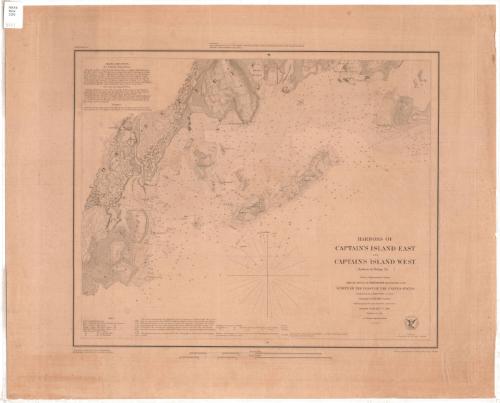
Harbors of Captain's Island East and Captain's Island West
PublisherPublished by
United States Coast Survey
American, founded 1807
SurveyorUnder the direction of
Ferdinand Rudolph Hassler
American, 1770 - 1843
SurveyorTriangulation by
James Ferguson
American, 1797 - 1867
SurveyorTopography by
Constant M. Eakin
French-American, 1794 - 1870
SurveyorHydrography by
George S. Blake
American, 1802 - 1871
DraftsmanDrawn by
William Luce
American, 1825 - 1863
PrintmakerEngraved by
Albert Rolle
German-American
Date1849
MediumEngraving; printer's ink on wove paper
DimensionsPrimary Dimensions (image height x width): 14 x 17 1/4in. (35.6 x 43.8cm)
Platemark (height x width): 17 3/4 x 21 1/4in. (45.1 x 54cm)
Sheet (height x width): 18 3/4 x 23in. (47.6 x 58.4cm)
Platemark (height x width): 17 3/4 x 21 1/4in. (45.1 x 54cm)
Sheet (height x width): 18 3/4 x 23in. (47.6 x 58.4cm)
ClassificationsGraphics
Credit LineGift of the Charleston Library Society
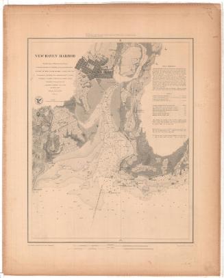
DescriptionChart of the coast of Greenwich, Connecticut from Minursen Island to Flat Neck Point, including the Byram River, Byram's Point, Horseneck Point, Bush's Harbor, Chimney Corner, and the mouth of Mannock's River. The nature of the terrain is indicated; elevation is indicated by hachure marks. Roads and buildings are shown, with a cluster of buildings in the village of Saw-Pits. Islands include Captain's Island East (Little Captain's Island) and Captain's Island West (Great Captain's Island), and Calf Island. Soundings are in feet, up to eighteen feet. Sailing directions are at upper left and an explanation of tides is at lower left.
Object number1995.205.2
InscribedOn recto, lower right, printed in black ink, "HARBORS OF CAPTAIN’S ISLAND EAST / AND / CAPTAIN’S ISLAND WEST / (Harbors of Refuge No. ) / From a Trigonomectrical Survey / Under the direction of F.R. HASSLER Superintendent of the / SURVEY OF THE COAST OF THE UNITED STATES / Triangulation by JAMES FERGUSON Assistants / Topography by C.M. Eakin, W.M. Boyce & J. Farley Assistants. / Hydrography by the party under the / command of / Lieutenant G.S. BLAKE U.S. Navy. / Published in 1849. / A. D. Bache Superintendent. / Scale 1/20,000 / Verified by A.A. Humphreys Lieu.t Eng.ts & Assistant"On recto, upper left, printed in black ink, “Harbor Map No.”
On recto, upper center, printed in black ink, " Presented to _______ / under the authority of an Act of Congress of the United States of June 3rd 1844 & by direction of the Treasury Department. / A.D. Bache Superintendent, Coast Survey."
On recto, lower left, printed in black ink, "Topography reduced by W. Luce, draughtsmen. / Hyrography reduced by W.C. Barney, Lt. U.S. Navy.”
On recto, lower left, printed in black ink, "Hills by A. Rolle. Title by W. Smith, and the rest by S.T. Petit.”
On verso, upper right, in pencil, "Deacidified / 12/10/01"
NotesCartographic Note: Scale 1/20,000
Collections
- Maps and Charts: Finding Your Place in Connecticut History
On View
Not on view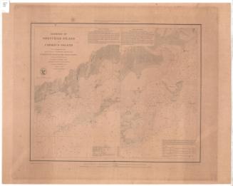

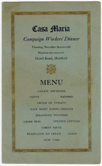
Sterling Press
1927 November 17