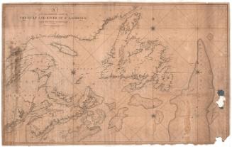
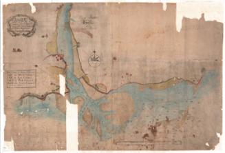
Blunt's New Chart of the North-Eastern Coast of North America
PublisherPublished by
Edmund March Blunt
1770 - 1862
PublisherPublished by
William Hooker
American, 1782 - 1856
Date1819
MediumEngraving; black printer's ink on paper
DimensionsPrimary Dimensions (image height x width): 38 1/4 x 62 3/8in. (97.2 x 158.4cm)
Sheet (height x width): 38 5/8 x 62 7/8in. (98.1 x 159.7cm)
Sheet (height x width): 38 5/8 x 62 7/8in. (98.1 x 159.7cm)
ClassificationsGraphics
Credit LineConnecticut Museum of Culture and History collection
DescriptionNautical chart of the Atlantic Ocean off the northeastern coast of North America, from New Jersey to Nova Scotia. The map is oriented east-west instead of north-south, with the land mass of North American to the east or top, the Bay of Fundy and Nova Scotia to the north or right, the ocean to the west or bottom and south or left. In the top right corner are insets of plans of Squam, Portland, Newport, Boston and Newbury Port Harbors, the last three of which include scales. Georges Bank is near the center of the chart. Along with depth measurements, shoals, banks, "green ooze," different colors and textures of sand, stones and pebbles are marked. There are two eight-point compass roses with a symbol marking north and four smaller 32-point compasses, one of which marks north.
Object number2012.312.136
MarkingsVerso, top left corner, printed on label: Advertisement for William Hooker's new editions of "that celebrated CHART, extending from NEW-YORK to HAVAN- / NA, containing PLANS of the principal Harbours, with Sailing Directions for entering Sandy Hook and / crossing the Bahama Banks, engraved on the Chart," and "a new CHART of EAST FLORIDA and BAHAMA BANKS." Also advertises nautical navigation equipment for sale, and ends with a note listing Edmund Blunt's "Nautical Works, still available at the "Old Stand."Top left corner, overlapping Hooker's advertisement, handwritten in black ink on paper adhered to verso: Titled "Ship Champion of Bath [illegible] New Orleans [illegible]," it is a log from Friday, June 12, 1829 to Thursday June 18, 1829. The entries include a short description of the wind and weather conditions, and a few sentences about events happening on the ship.
InscribedRecto, top right: "BLUNT'S / NEW CHART / OF THE / NORTHEASTERN COAST / OF / NORTH AMERICA / EXTENDING FROM / Lat. 39.°30' N. Long. 74.°8' W. to Lat. 45.° N. Long. 66.° W."
Top right, printed in black ink: "New York. Published as the Act directs, June 1813. / IMPROVED 10 April 1819 by the Author. PUBD. / BY WILLIAM HOOKER, / (Successor to E.M. Blunt) / 202 WATER STREET / NEW YORK."
Verso, top left, handwritten in black ink: "[illegible] Coast 4th"
Lighthouses are marked in red ink.
Several pencil points and inscriptions marking a location: "Sunday / Sept 15th," "19 Sept." Other penciled dots do are inscribed only with a number, and some are illegible.NotesCartographic Note: Scale (main map): Sixty miles equals twenty leagues. The insets also have scale rulers, but only contain one unit of measurement, either statute or nautical miles.
Collections
- Maps and Charts: Finding Your Place in Connecticut History
On View
Not on view