Picolata, East Florida
PrinterPrinted by
D. W. Kellogg & Co.
American, 1830 - 1840
DateProbably 1830-1835
MediumLithography; printer's ink on wove paper
DimensionsPrimary Dimensions (image height x width): 17 1/4 x 12 3/4in. (43.8 x 32.4cm)
Sheet (height x width): 18 5/8 x 14in. (47.3 x 35.6cm)
Sheet (height x width): 18 5/8 x 14in. (47.3 x 35.6cm)
ClassificationsGraphics
Credit LineConnecticut Museum of Culture and History collection
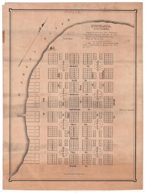
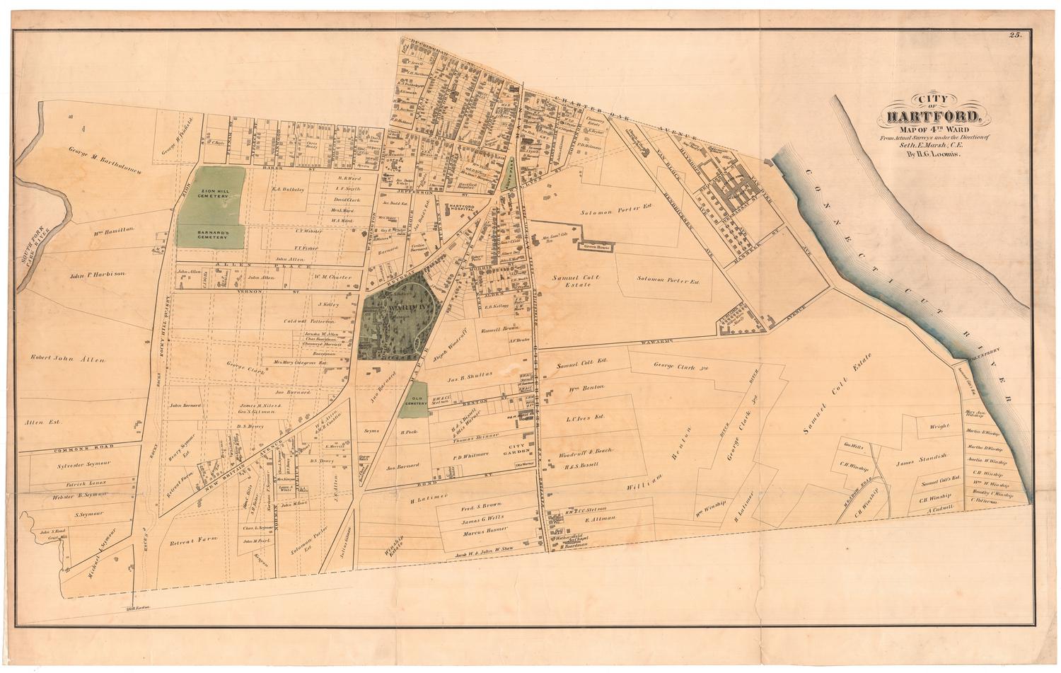
DescriptionMap of building lots in Picolata, Florida, on the east side of the St. Johns River, pictured on the map. The lots are grouped in clusters of 48, situated around named squares and woods. Running north-south are Bay Street, Oak Street, King Street, Cherry Street, Stephens Street and Broad Street; running east-west are Hickory, Hall, Mulberry, Oglethorpe, Olive, Duncan, Vine and South Streets. At the top of the map is a depiction of a two story building with smoke coming out of its twin chimneys; it is labeled "Picolata House." Above it and to the right is a stand of six trees, named "Picolata Place." West of Bay Street, the closest road to the river, are 21 wharf lots. Numbers 11 and 12 extend into the river, and are labeled, "Wharf."
Object number1991.188.0
MarkingsRecto, top left, printed in black ink on sticker: "MAPS / Box / 189"Verso, center, stamped in blue ink: "CtHi"InscribedRecto, top, handwritten in pencil: "Speculation Bubble"
Top, printed in black ink: "PICOLATA, / EAST FLORIDA, / Situated 18 miles west from St. Augustine, / on the St. Johns River, 70 miles from the Sea. / Building Lots, 60 feet front, 100 feet deep, / Wharf Lots, 100 feet front. / A Treaty was held at Picolata, between Great Britain and the Indians of Florida, on the 18th of Novr. 1765."
Verso, top left, handwritten in pencil: "Maps / Flat / 83"
Top, handwritten in brown ink: "Ch.[illegible] Hensen(?)"
Top, handwritten in brown ink: "Picolata"
Center, handwritten in pencil: "90724"NotesCartographic Note: No scale
Subject Note: The Picolata House, which appears at the top of the map, was a hotel owned and operated by John P. Levy. In an announcement published in the Jacksonville Courier in 1835, Levy revealed that the hotel, which apparently had been in existence prior to the announcement, was "greatly enlarged, will comfortably accommodate a numerous company, the Rooms will be well furnished and the Table richly supplied with the best fare the country affords."
Jacksonville Courier, November 19, 1835.
Collections
- Maps and Charts: Finding Your Place in Connecticut History
On View
Not on view

Sherman Wolcott Adams
1885