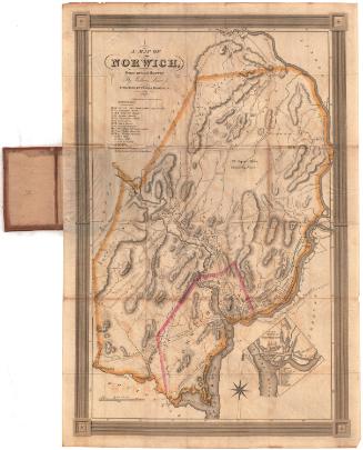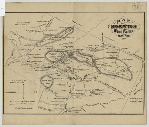
Map of Norwich, West Farms, 1663-1725
MakerCompiled by
Dr. Ashbel Woodward
American
PrinterPrinted by
Punderson, Crisand & Co.
American, 1869 - 1873 or 1874
Date1869
MediumLithography; black printer's ink on wove paper
DimensionsPrimary Dimensions (image height x width): 7 3/8 x 10 1/8in. (18.7 x 25.7cm)
Sheet (height x width): 8 7/8 x 10in. (22.5 x 25.4cm)
Sheet (height x width): 8 7/8 x 10in. (22.5 x 25.4cm)
ClassificationsGraphics
Credit LineConnecticut Museum of Culture and History collection
DescriptionMap of Norwich, Connecticut, oriented east-west, with Windham or Naubactug to the north, the Shetucket River to the east, Scotch Gap tot he south, and Lebanon to the west. Officially depicting the town from 1663 to 1725 (but including dates into the 1800s), it shows the locations of mills, churches and burying grounds, and the names of residents and where they lived. Physical features such as hills, swamps, plains and rivers are included. Elevation is denoted with hachure marks.
Object number2012.312.199
MarkingsRecto, top left corner, printed in black ink on sticker: "MAPS / Box / 249"InscribedRecto, top right, handwritten in pencil: "75 [circled]"Top right, printed in black ink: "MAP / OF / NORWICH / West Farms / 1663.1725."
Bottom right, printed in black ink: "Lith. of Punderson Crisand & Co. New Haven, Ct."
Verso, top left corner, handwritten in pencil: "Maps / Flat / 57"NotesCartographic Note: No scale
Collections
- Maps and Charts: Finding Your Place in Connecticut History
On View
Not on view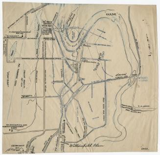
Dr. Ashbel Woodward