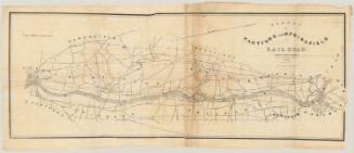
Plan of Hartford and Springfield Rail-Road
DraftsmanDrawn by
Philander Anderson
1810 - 1853
PrintmakerEngraved by
J. H. Goldthwait
American
Dateprobably 1841-1844
MediumEngraving; black printer's ink on wove paper
DimensionsPrimary Dimensions (image height x width): 7 7/8 x 31 1/4in. (20 x 79.4cm)
Sheet (height x width): 10 1/4 x 33 1/2in. (26 x 85.1cm)
Sheet (height x width): 10 1/4 x 33 1/2in. (26 x 85.1cm)
ClassificationsGraphics
Credit LineMuseum purchase
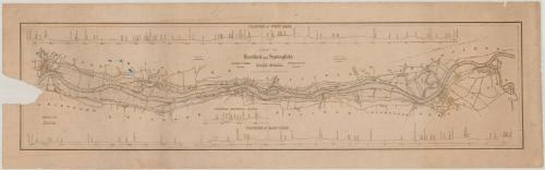
DescriptionMap of the Hartford and Springfield Railroad, oriented horizontally on the map so that Hartford is on the left side of the sheet and Springfield is on the right. The west line, from Hartford to Springfield, is shown running along the west side of the Connecticut River on the map, with its profile apearing at the top of the map. The east line, from Springfield to Hartford, is shown running along the east side of the Connecticut River, with its profile appearing at the bottom. Above the east line profile near the center is a profile of where the lines cross the river. Some of the streets of Hartford and Springfield are delineated but not named, and the names of the towns along both lines are included.
Object number1960.143.2
MarkingsRecto, top and bottom left corners, printed in black ink on sticker: "MAPS / Drawer / 20"Verso, bottom, handwritten in pencil on sticker: "1073"
InscribedRecto, top, handwritten in pencil: "1839-41 / Not in Thompson"
Center, printed in black ink: "PLAN OF / Hartford and Springfield / RAIL-ROAD. / (APPROXIMATE LOCATION.) / Drawn by / P. ANDERSON. / Alexander C. Twining / Engineer. / Philander Anderson / Assistant. / Engraved by / J.H. GOLDTHWAIT / Springfield."
Left side, printed in black ink: "Horizontal Scale / 5000 ft. to the inch. / Vertical Scale / 240 ft. to the inch."
Verso, top, handwritten in pencil: "MAP BOX #87"NotesCartographic Note: Horizontal scale: 1 inch equals 5000 feet; vertical scale: 1 inch equals 240 feet
Collections
- Maps and Charts: Finding Your Place in Connecticut History
On View
Not on view