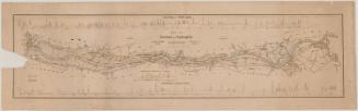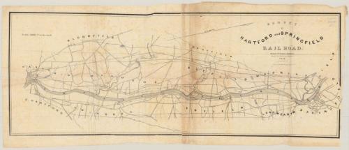
Survey of Hartford and Springfield Rail Road
SurveyorSurveyed by
James N. Palmer
American, about 1803 - 1866
DraftsmanDrawn by
Charles Buck
1817 - 1845
PrinterPrinted by
E.B. & E.C. Kellogg
American, 1840 - 1867
Date1841
MediumLithography; black printer's ink on wove paper
DimensionsPrimary Dimensions (image height x width): 10 3/8 x 28in. (26.4 x 71.1cm)
Sheet (height x width): 12 x 29 1/4in. (30.5 x 74.3cm)
Sheet (height x width): 12 x 29 1/4in. (30.5 x 74.3cm)
ClassificationsGraphics
Credit LineConnecticut Museum of Culture and History collection
DescriptionMap from Hartford, Connecticut, to Springfield, Massachusetts, oriented east-west on the map, with Hartford on the left, Springfield on the right, and the Connecticut River on the bottom. The towns between the two cities are labeled, and what are presumably roads are denoted with parallel solid lines but are not labeled. The potential railroad routes are depicted with solid single lines. There are various routes running between Hartford and Springfield; at least two are identified as the Hartford and New Haven Railroad and the Western Railroad, while the others are unlabeled. Other notable landmarks include Kings Island and the Farmington, Scantic, Mill and Fresh Water Rivers. The magnetic north arrow at the top of the map points toward the top right corner.
Object number2012.312.48
MarkingsRecto, top left, printed in black ink on sticker: "MAPS / Box / 266"Verso, bottom, handwritten in pencil on sticker: "1058"InscribedRecto, top right, printed in black ink: "SURVEY / OF / HARTFORD AND SPRINGFIELD / RAILROAD. / James N. Palmer. Engineer / Drawn by C. Buck, Asst. Engineer. / 1841"
Top right, printed in black ink: "Lith. of E.B. & E.C. Kellogg Hartford, Ct."
Verso, top left corner, handwritten in pencil: "Maps / Flat / 152"
Top right corner, handwritten in pencil: "Deacidified / 10/25/99"NotesCartographic Note: Scale: 1 inch equals 5000 feet
Collections
- Maps and Charts: Finding Your Place in Connecticut History
On View
Not on view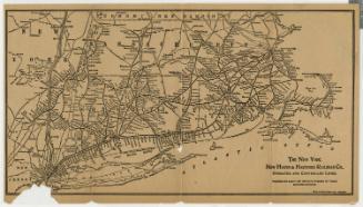
Rand Avery Supply Co.
about 1900