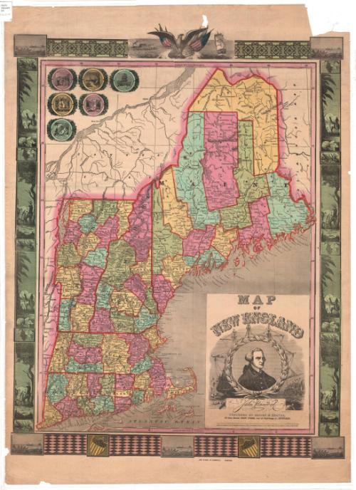
Map of New England
PrinterPrinted by
Ensign & Thayer
American, 1849 - 1850
After a work byAfter a work by
Lossing-Barritt
American, 1846 - 1869
PublisherPublished by
Ensign & Thayer
American, 1849 - 1850
PublisherPublished by
Joseph Ward
American
Date1847
MediumLithography; black ink and watercolor on wove paper
DimensionsPrimary Dimensions (image height x width): 28 1/8 x 22 3/8in. (71.4 x 56.8cm)
Sheet (height x width): 31 7/8 x 23 5/8in. (81 x 60cm)
Sheet (height x width): 31 7/8 x 23 5/8in. (81 x 60cm)
ClassificationsGraphics
Credit LineConnecticut Museum of Culture and History collection
DescriptionMap of New England, from the border of Canada to the north and east, the Atlantic Ocean to the south, and New York State to the west. State and county borders are marked in broken solid lines, colored red; counties are also colored, either yellow, blue, green or pink. Cities are marked with circles and are labeled. Towns boundaries are not provided. Physical features include mountains, conveyed through hachure marks; rivers, lakes; and islands. Railroads are marked with crossed lines and are not labeled. Above the map to the left are six circles, one for each New England state, within which are the state seal on a square surrounded by other state symbology. At the top, the decorative border features the bald eagle with the American flag and shield and an olive branch, a ship at sea on the right and a town on the left. Other elements in the border include geometric patterns, the American shield, and scenes meant to evoke New England. The cartouche features a portrait of John Hancock, surrounded by a wreath; behind this is a depiction of the Boston Tea Party.
Object number2012.312.145
MarkingsRecto, top left, printed in black ink on sticker: "MAPS / Drawer / 64"InscribedRecto, lower right, printed in black ink: "MAP / OF / NEW ENGLAND / John Hancock / PUBLISHED BY ENSIGN & THAYER, / 50 Ann Street, NEW YORK, and 12 Exhange st., BUFFALO. / Entered according to act of Congress, in the year 1847, by ENSIGNS & Thayer, in the Clerk's office, for the Southern District of New York"Center bottom, printed in black ink: "JOS. WARD, 52 CORNHILL BOSTON."
Verso, bottom left, handwritten in black ink: "Print / Drw 2 / #26"NotesCartographic Note: No scale
Medium Note: It seems likely that this map is a transfer lithograph, based on (or incorporating) wood-engravings by the firm Lossing-Barritt.
Collections
- Maps and Charts: Finding Your Place in Connecticut History
On View
Not on view


Thayer, Bridgman & Fanning
1853


Object/Object