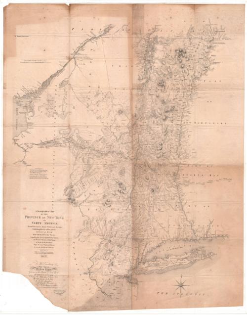
A Chorographical Map of the Province of New York in North America
PublisherPublished by
David Vaughan
After a work byAfter a work by
Claude Joseph Sauthier
French, 1736 - 1802
After a work byAfter a work published by
William Faden
British, 1750 - 1836
Date1849
MediumLithography; black printer's ink on wove paper
DimensionsPrimary Dimensions (image height x width): 37 7/8 x 29 1/2in. (96.2 x 74.9cm)
Sheet (height x width): 37 7/8 x 29 1/2in. (96.2 x 74.9cm)
Sheet (height x width): 37 7/8 x 29 1/2in. (96.2 x 74.9cm)
ClassificationsGraphics
Credit LineConnecticut Museum of Culture and History collection
DescriptionMap of New York, with Canada to the north; parts of New Hampshire, Massachusetts and Connecticut to the east; the Atlantic Ocean and New Jersey to the south; and Pennsylvania, the "Six Nations Indian Country" and Lake Ontario to the west. Relief is conveyed through hachures. Various lines are used to denote county boundaries and real property. Some railroads or other transportation lines appear to be marked but not labeled. Physical features include mountains, conveyed through hachure marks; lakes; rivers; and waterfalls.
Object number2012.312.140
MarkingsRecto, top left corner, printed in black ink on sticker: "MAPS / Drawer / 56"InscribedRecto, left, printed in black ink: "ADVERTISEMENT / The Tracts of Land coloured Red are Military Grants / according to his Majesty's Proclamation in October 1763. / Those with a Green edge are Manors, and those / coloured Yellow are Townships. / ---- A Line under a Name denote the Land / claimed by the Province of New Hampshire. / NB. The Mohawk River and COunty of Tryon are / Laid down according to an Actual Survey and other / Manuscripts generously communicated by Govt. Pownall."Left, printed in black ink: "A Chorographical MAP / OF THE / PROVINCE OF NEW YORK / IN / NORTH AMERICA, / Divided into Counties Manors Patents and Townships; / Exhibiting ilkewise all the private / GRANTS OF LAND / made and located in that Province, / Compiled from ACTUAL SURVEYS deposited in / the PATENT OFFICE at New York, / By Order of His Excellency / Major General WILLIAM TRYON / By CLAUDE JOSEPH SAUTHIER Esqr / LONDON / Engraved and Published by WILLIAM FADDEN, / (Successor to the late Thos. Jefferys Geog to the KING) / CHARING CROSS, / January 1st 1779."
Bottom left, printed in black ink: "To His Excellency / Major General / William Tryon, / Governor of the Province of New York / and the Islands thereunto belonging, / Colonel of His MAJESTY'S 70th Regt of Foot, / This MAP undertaken by His Order / Is with His Permission / most humbly Inscribed / by His Excellencys most obliged / devoted and obedient Servant / CLAUDE JOSEPH SAUTHIER / REDUCED FROM THE ORIGINAL LARGE LONDON MAP / By DAVID VAUGHAN 1849"
Verso, top, handwritten in pencil: "Maps / flat / 126"NotesCartographic Note: About 7/8 inches equals 10 miles; 69 1/2 miles to a degree
Collections
- Maps and Charts: Finding Your Place in Connecticut History
On View
Not on view


H. F. Sumner & Co.
1833


Thomas Sedgwick Steele
1881