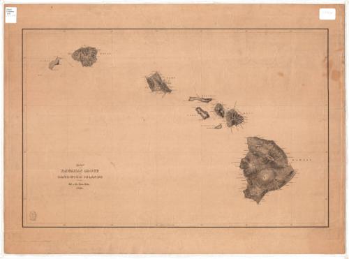
Map of the Hawaiian Group or Sandwich Islands
SurveyorSurveyed by
United States Exploring Expedition
American, 1838 - 1842
PrintmakerEngraved by
Sherman and Smith
American, 1840 - 1853
Date1844
MediumEngraving; black printer's ink on wove paper
DimensionsPrimary Dimensions (image height x width): 15 5/8 x 23 3/4in. (39.7 x 60.3cm)
Platemark (height x width): 17 3/4 x 25 3/4in. (45.1 x 65.4cm)
Sheet (height x width): 19 3/4 x 26 1/2in. (50.2 x 67.3cm)
Platemark (height x width): 17 3/4 x 25 3/4in. (45.1 x 65.4cm)
Sheet (height x width): 19 3/4 x 26 1/2in. (50.2 x 67.3cm)
ClassificationsGraphics
Credit LineConnecticut Museum of Culture and History collection
DescriptionRelief map of the eight Hawaiian Islands: Nihau, Kauai, Oahu, Molokai, Lanai, Kahoolawe, Maui and Hawaii. Elevation is conveyed with hachure marks, and coastal places, volcanoes, and passages are labeled. Lines of latitude and longitude, marked by degrees, are inscribed around the edges of the image area. The seal of the United States Exploring Expedition is located in the bottom left corner.
Object number2012.312.97
MarkingsRecto, top left corner, printed in black ink on sticker: "Maps / Drawer / 106"Top right corner, handwritten in pencil on sticker: "1844"InscribedRecto, bottom left, printed in black ink: "MAP / OF HAWAIIAN GROUP / OR SANDWICH ISLANDS / BY THE / U.S. Ex. Ex. / 1844."
Bottom right, printed in black ink: "Eng. by Sherman & Smith, N.Y."
Verso, top right corner, handwritten in pencil: "Map / Folio / #24"
Bottom right corner, handwritten in pencil: "Print / Drw 2 / #24"NotesCartographic Note: No scale
Collections
- Maps and Charts: Finding Your Place in Connecticut History
On View
Not on view