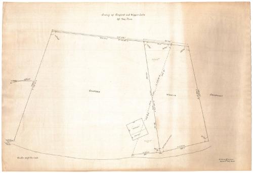
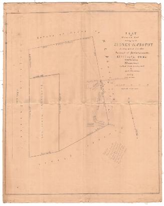
Survey of Sanford and Wiggin Lots, Mt. Tom Pond
SurveyorSurveyed by
Samuel Palmer Griffin
American, 1862 - 1922
Date1915
MediumDrawing; black ink on wove paper
DimensionsPrimary Dimensions (image height x width): 13 1/2 x 21in. (34.3 x 53.3cm)
Sheet (height x width): 15 1/8 x 22 1/4in. (38.4 x 56.5cm)
Sheet (height x width): 15 1/8 x 22 1/4in. (38.4 x 56.5cm)
ClassificationsGraphics
Credit LineConnecticut Museum of Culture and History collection
DescriptionPlat map of the Sanford and Wiggins lots in Litchfield, Connecticut, showing the old and new lines, and including geographical bearings and measurements in feet and inches along all of the boundary lines. The Sanford property includes two structures, "Nokomis" and a piazza, and in the lower left corner, the edge of the lot is marked by the "north big rock or spilt rock." To the left of the map, the north arrows indicate true and magnetic north, and they show that the map is oriented east-west.
Object number2012.312.43
MarkingsRecto, center, stamped in blue ink: "CtHi"InscribedRecto, top center, handwritten in black ink: "SURVEY of Sanford and Wiggins Lots / Mt. Tom PoND"Bottom right corner, handwritten in black ink: "S.P. GRiffiN, M.E. / MARCH 20, 1915."
Bottom left corner, handwritten in black ink: "Scale: 20 ft to 1 inch"
Verso, right, handwritten in pencil: Sanford plot / MT Tom pond (1915)"
NotesCartographic Note: Scale: 1 inch equals 20 feet
Collections
- Maps and Charts: Finding Your Place in Connecticut History
On View
Not on view


Sherman Wolcott Adams
1885