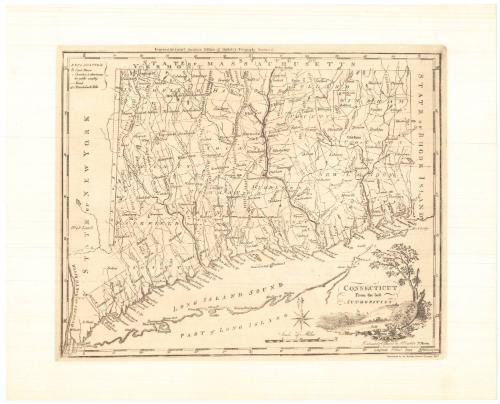
Connecticut From the best Authorities
PrinterPrinted by
Meriden Gravure Company
American, 1888 - 1977
After a work byAfter a work by
Amos Doolittle
American, 1754 - 1832
Date1957
MediumPhotomechanical reproduction; black ink on wove paper
DimensionsPrimary Dimensions (image height x width): 12 1/4 x 15 1/8in. (31.1 x 38.4cm)
Sheet (height x width): 15 1/4 x 19in. (38.7 x 48.3cm)
Sheet (height x width): 15 1/4 x 19in. (38.7 x 48.3cm)
ClassificationsGraphics
Credit LineConnecticut Museum of Culture and History collection
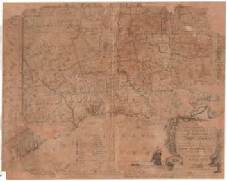
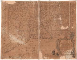
DescriptionReproduction of Amos Doolittle's map of Connecticut, with the borders of Vermont and Massachusetts to the north, Rhode Island to the east, part of Long Island and the Long Island Sound to the south, and New York to the west. Counties and towns are shown, as well as courthouses and churches. Elevation is depicted with clusters of peaks. The cartouche is decorative, with the state seal and motto lying next to a tree on the shoreline.
Object number2012.312.36
MarkingsVerso, center, stamped in blue ink: "CtHi"InscribedRecto, top, printed in black ink: "Engraved for Carey's American Edition of Guthrie's Geography Improved"Bottom right, printed in black ink: "CONNECTICUT / From the best / AUTHORITIES"
Bottom right, printed in black ink: "Delineated & Engraved by A Doolittle N. Haven."
Bottom right, printed in black ink: "Reproduced by the Meriden Gravure Company, 1957"
Verso, left side, handwritten in pencil: "1794-5 / Repro 1957"NotesCartographical Note: Scale on the original map: About 3/4 inch equals about 6 miles
Collections
- Maps and Charts: Finding Your Place in Connecticut History
On View
Not on view
Joel Knott Allen
1792
Joel Knott Allen
1791 or 1792


Lucius Stebbins & Co.
1859