Old Connecticut Path, from Larned's History Windham County
After a work byAfter a work by
Chauncey G. Keeney
American, about 1810 - 1888
DraftsmanDrawn by
Unknown
Dateafter 1880
MediumLithography; black printer's ink on wove paper
DimensionsPrimary Dimensions (image height x width): 9 3/8 x 9in. (23.8 x 22.9cm)
Sheet (height x width): 11 3/4 x 11in. (29.8 x 27.9cm)
Sheet (height x width): 11 3/4 x 11in. (29.8 x 27.9cm)
ClassificationsGraphics
Credit LineConnecticut Museum of Culture and History collection
DescriptionPocket map of part of the Old Connecticut Path in Ashford, Windham County, Connecticut. The area is divided into nine districts or wards, with local roads and landowners labeled. The Path is marked with a thick black line. Rivers are also depicted. In the top right is an inset map of Westford, a village within the town of Ashford. At the bottom is an explanation of what the Old Connecticut Path was ("Indian trail when John Oldham cruised these wilds in 1633)..
Object number2004.146.0
MarkingsRecto, bottom right, stamped in purple ink: "David E. Chism / Petersham, Mass."Verso, top right, stamped in black ink: "Connecticut Historical Society / Library"InscribedRecto, bottom, printed in black ink: "Old Conn. Path from Larned's History of Windham Co. / Laid on C.G. Keaney's Map of 1869"
Bottom left, handwritten in pencil: "For your files"
Verso, top, handwritten in pencil: "Old Connecticut Path"
Top right, handwritten in pencil: "98545"NotesCartographic Note: No scale
Collections
- Maps and Charts: Finding Your Place in Connecticut History
On View
Not on view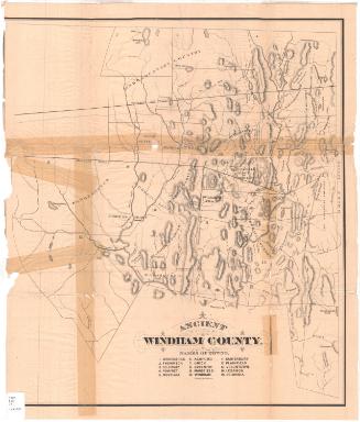
Ithamar P. Berthrong
1908


Towne Crier Marketing, Inc..
1998