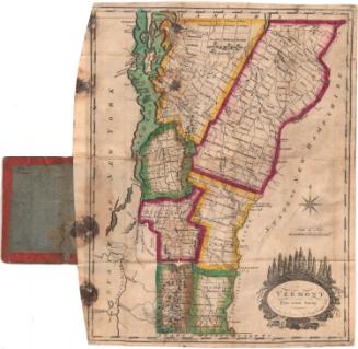
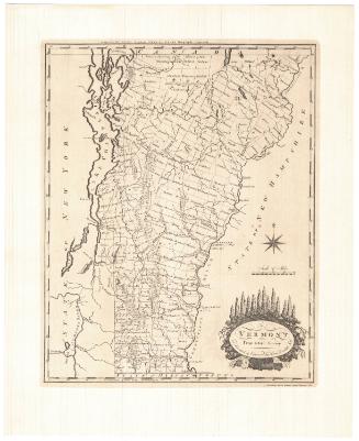
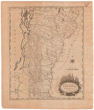
Vermont
PrintmakerEngraved by
Moody M. Peabody
American, 1787 - 1856
PublisherPublished by
Zadock Thompson
American, 1796 - 1856
Datebefore 1824
MediumEngraving; black printer's ink on wove paper in paper covers
DimensionsPrimary Dimensions (image height x width): 8 3/4 x 5 5/8in. (22.2 x 14.3cm)
Sheet (height x width): 9 1/2 x 6 1/2in. (24.1 x 16.5cm)
Sheet (height x width): 9 1/2 x 6 1/2in. (24.1 x 16.5cm)
ClassificationsGraphics
Credit LineGift of Samuel St. John Morgan
DescriptionPocket map of Vermont, with Canada to the north, New Hampshire to the east, Massachusetts to the south, and New York to the west. The state is divided into counties and towns. Physical features depicted include elevation, conveyed with clusters of peaks, rivers, and lakes. The decorative cartouche features an eagle over a mountain range, holding a banner with the state motto, "Freedom and Unity," in its talons.
Object number1956.96.1
MarkingsVerso, center, stamped in blue ink: "CtHi"InscribedFront cover, gold tooled: "VERMONT"Inside cover, top left, handwritten in blue ink: "64513"
Top left, handwritten in pencil: "Maps / 65413"
Recto, lower right side, printed in black ink: "VERMONT"
Bottom left, printed in black ink: "Engraved for Thompson's Gazetteer of Vermont."
Bottom right, printed in black ink: "Peabody Sc."
Verso, handwritten in black ink: [list of names]
Handwritten in pencil: [James 5:16 verse]
Center, handwritten in pencil: "65413"
NotesCartographic Note: Scale: 1 inch equals 20 miles
Collections
- Maps and Charts: Finding Your Place in Connecticut History
On View
Not on view