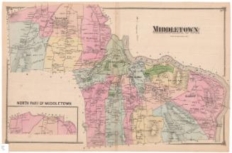
Map of the City of Middletown, Connecticut
SurveyorSurveyed by
R. Whiteford
American
PrintmakerLithographed by
John F. Watson
American, active 1835 - 1861
PublisherPublished by
Richard Clark
American
Date1851
MediumLithography; black printer's ink and watercolor on wove paper mounted on fabric
DimensionsPrimary Dimensions (image height x width): 35 1/2 x 45 1/4in. (90.2 x 114.9cm)
Sheet (height x width): 38 1/4 x 46 1/2in. (97.2 x 118.1cm)
Sheet (height x width): 38 1/4 x 46 1/2in. (97.2 x 118.1cm)
ClassificationsGraphics
Credit LineConnecticut Museum of Culture and History collection
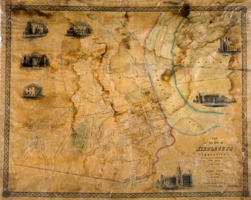
DescriptionMap of the city of Middletown on the west side of the Connecticut River and part of the town of Portland on the east side of the river. Willow island, the navigation channel, the Little River, and another unnamed river are shown. Elevation is indicated by hachure marks and many hills are named. Streets and roads are named and buildings are accompanied by the names of their owners. The Middletown and Berlin Railroad and its depot are at upper center. Indian Hill Cemetery and other burial grounds are colored green. In Portland, the brownstone quarries figure prominently, and districts near the river are identified as Belfast, Cork, and Dublin. Vignettes at left and right, based on daguerreotypes by Samuel Brewer, depicta view on Main Street, Wesleyan University, the Episcopal Church in Portland, and the residences of Nathan Starr, Mrs. R. Alsop, Samuel Russell, and William Cooley, Jr.
Object number2012.312.282
MarkingsOn verso. upper left, on gummed label, typed in black ink, "MAPS / Case 3 / No. 5"On verso, upper right, on gummed label, typed in black ink, "MAPS / Case 3 / No. 5"InscribedOn recto, lower right, printed in black ink, "MAP / OF THE CITY OF / MIDDLETOWN / CONNECTICUT / FROM ORIGINAL SURVEYS BY R. WHITEFORD SURVR. / NEW HAVEN. / PUBLISHED BY RICHARD CLARK / No. 384 S. THIRD ST. / PHILADELPHIA / 1851. / WATSON'S LITH. PHILA. / Population of City: 4228 / do. [Population] of Portland: 2905"
On recto, lower right, printed in black ink, "Entered according to act of Congress in the year 1851 by Richd. Clark, in the Clerks Office of the District Court of the Eastern District of Penn."
On verso, upper left, in pencil, "MAPS / Case 3 / No. 5"
On verso, upper right, in pencil, "MAPS / Case 3 / No. 5"
On verso, lower right, in pencil, "2012.312.282"NotesCartographic Note: 2 1/2 inches equals approximately 700 feet
Constituent Note: Samuel Brewer was a daguerreotypist who appears in the Hartford city directory for 1847.
Collections
- Maps and Charts: Finding Your Place in Connecticut History
On View
Not on view