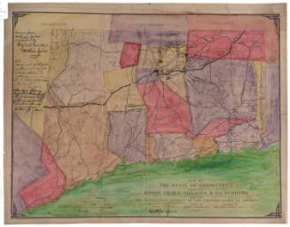
Woodland Trails near Bristol
MakerData by
Romeyn A. Spare
American, 1885 - 1968
PublisherPublished by
Connecticut Forest and Park Association
American, founded 1895
DraftsmanDrawn by
Perry N. Deming
American, 1888 - 1962
Date1933
MediumBlueprint; cyanotype on wove paper
DimensionsPrimary Dimensions (image height x width): 21 1/2 x 15in. (54.6 x 38.1cm)
Sheet (height x width): 22 x 15 1/2in. (55.9 x 39.4cm)
Sheet (height x width): 22 x 15 1/2in. (55.9 x 39.4cm)
ClassificationsGraphics
Credit LineGift of Gary W. Potter
DescriptionMap of the Tunxis Trail system in Bristol, Connecticut, and the surrounding communities of Collinsville, Canton, Unionville, Farmington, Burlington, Harwinton, Plantsville, Plymouth, Terryville, and Wolcott. Parts of the Mattatuck, Metacomet, and Qunnipiac Trails are also shown. Major features include the Nepaug Reservoir, Buttermilk Falls and other waterfalls, a fish hatchery, a coppermine, a log cabin, a quarry, an unconformity, the Devil's Kitchen, the Johnnycake Mountain Fire Tower, and Tories Den. Major state highways include Routes 10, 6, 177, 167, 101, and 117. Small cartoon figures include hikers, rock climbers, a man cooking over a campfire, and a woman wading in a pond.
Object number2012.548.3
InscribedOn recto, upper left, in cyanotype, "WOODLAND TRAILS NEAR BRISTOL / TUNXIS TRAIL, ITS LOOPS, CROSSOVERS / FEEDERS, AND OTHER BLUE-BLAZED / TRAILS SHOWN THUS - - - - / NUMBERS INDICATE CONVENIENT APPROACHES / CONN. FOREST AND PARK ASSOCIATION. / 115 CHURCH NEW HAVEN"; left center, "Corrected to 5-25-33"On verso, lower right, in pencil, "2012.548.3"NotesCartographic Note: One inch equals one mile
Collections
- Maps and Charts: Finding Your Place in Connecticut History
On View
Not on view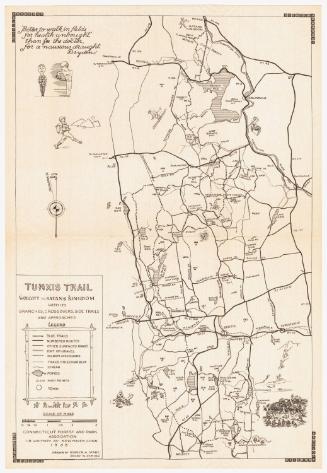


Tamara Gregorieff
1924, 1943-1945, 1957-1958