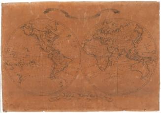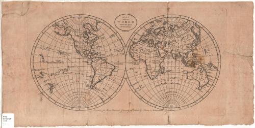
Map of the World from the best Authorities
PrintmakerEngraved by
Amos Doolittle
American, 1754 - 1832
PublisherPublished by
Thomas & Andrews
American, active 1793 - 1814
Date1796
MediumEngraving; black printer's ink on laid paper
DimensionsPrimary Dimensions (image height x width): 7 1/8 x 14in. (18.1 x 35.6cm)
Platemark (height x width): 7 7/8 x 14 5/8in. (20 x 37.1cm)
Sheet (height x width): 9 1/8 x 18 3/8in. (23.2 x 46.7cm)
Platemark (height x width): 7 7/8 x 14 5/8in. (20 x 37.1cm)
Sheet (height x width): 9 1/8 x 18 3/8in. (23.2 x 46.7cm)
ClassificationsGraphics
Credit LineConnecticut Museum of Culture and History collection
DescriptionMap of the world, with the western hemisphere on the left and the eastern hemisphere on the right. All of the continents except for Antarctica are depicted, and many countries are named but not demarcated. Lines of latitude and longitude are marked every ten degrees, and the Antarctic Circle, Tropic of Capricorn, Tropic of Cancer, and the Arctic Circle are also shown. The only physical features shown on the map are rivers, of which only major rivers are named.
Object number2005.196.0
MarkingsRecto, bottom left corner, printed in black ink on sticker: "Map / Drawer / 103 / [98937] [in pencil]"InscribedRecto, top, printed in black ink: "MAP / OF THE / WORLD / FROM THE BEST / AUTHORITIES / Doolittle Sculp."Bottom, printed in black ink: "Engraved for Morse's Universal Geography. Published by Thomas & Andrews, Boston."
Verso, left side, handwritten in pencil: "Map / Folio 2 / #4"
Left side, handwritten in pencil: "Drawer 6" [underlined]NotesCartographic Note: No scale
Collections
- Maps and Charts: Finding Your Place in Connecticut History
On View
Not on view