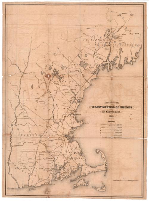
A Map of the Yearly Meeting of Friends for New England
PrintmakerEngraved by
George G. Smith
American, 1795 - 1878
Date1850
MediumEngraving; black printer's ink on wove paper
DimensionsPrimary Dimensions (image height x width): 22 3/8 x 16 1/4in. (56.8 x 41.3cm)
Sheet (height x width): 22 3/8 x 16 5/8in. (56.8 x 42.2cm)
Sheet (height x width): 22 3/8 x 16 5/8in. (56.8 x 42.2cm)
ClassificationsGraphics
Credit LineConnecticut Museum of Culture and History collection
DescriptionMap of the New England states along the Atlantic coast, minus Vermont, northern Maine, and Connecticut and Massachusetts west of the Connecticut River. The map shows the locations of the different Quaker meetings held throughout the year, including the yearly meeting, which was held in Newport, Rhode Island. Circles are used to denote the locations of cities that hold quarterly meetings, monthly meetings, preparation meetings and meetings for worship; squares are used to denote towns that do not hold Quaker meetings of any kind.
Object number1990.180.0
MarkingsVerso, center, stamped in blue ink: "CtHi"InscribedRecto, right side, printed in black ink: "A MAP OF THE / YEARLY MEETING OF FRIENDS / for New England. / 1850 / Engraved by Geo. G. Smith"Verso, top left corner, handwritten in pencil: "Maps / Flat / 44"
Center, handwritten in pencil: "90062"NotesCartographic Note: Scale: 7/8 inch equals 10 miles
Collections
- Maps and Charts: Finding Your Place in Connecticut History
On View
Not on view
1912


30 June 2025