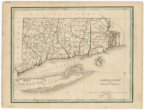
Connecticut and Rhode Island
PublisherPublished by
Thomas Gamaliel Bradford
American, 1802 - 1887
Date1842
MediumEngraving; black printer's ink and watercolor on wove paper
DimensionsPrimary Dimensions (image height x width): 7 7/8 x 10in. (20 x 25.4cm)
Sheet (height x width): 8 3/4 x 11 1/2in. (22.2 x 29.2cm)
Sheet (height x width): 8 3/4 x 11 1/2in. (22.2 x 29.2cm)
ClassificationsGraphics
Credit LineMuseum purchase
DescriptionMap of the states of Connecticut and Rhode Island, with the borders of Massachusetts to the north and east, Long Island and the Long Island Sound to the south, and New York to the west. Connecticut is outlined in red and Rhode Island in green, with the opposite color used to outline the counties in each state. Hartford and New Haven are both marked as capital cities, with a black-and-white line between them that might indicate a railroad. A similar line indicates the Housatonic Railroad; and in eastern Connecticut, what is probably the Norwich and Westerly Railroad line is depicted. A fourth line depicts what is probably the Stonington Line of the New York, New Haven and Hartford Railroad, between Stonington, Connecticut, and Providence, Rhode Island. The Farmington and Blackstone Canals are both shown. In the northwest corner of Connecticut, there is a proposed canal that at least partially surrounds Salisbury. Physical features include elevation, conveyed through hachure marks, and rivers and lakes are shown.
Object number1946.19.2
MarkingsVerso, center, stamped in blue ink: "CtHi"InscribedRecto, top left corner, handwritten in red ink: "55230"Left side, printed in black ink: "27"
Bottom right, printed in black ink: "CONNECTICUT / AND / RHODE ISLAND"
Bottom right corner, handwritten in pencil: ""P770i" / 1843-4"
Verso, center, handwritten in pencil: "55230"
Right side, handwritten in black grease pencil: "14" [circled]
Bottom left corner, handwritten in pencil: "MAP BOX / 14"
Bottom right, handwritten in pencil: "55230"
NotesCartographic Note: Scale: About 5/8 inches equals 10 miles
Collections
- Maps and Charts: Finding Your Place in Connecticut History
On View
Not on view


H. F. Sumner & Co.
1833


Object/Object