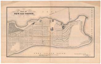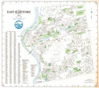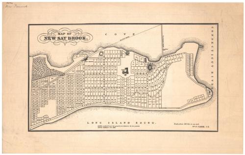
Map of New Say Brook
SurveyorSurveyed by
William R. Clarke
American
DraftsmanDrawn by
William R. Clarke
American
PrinterProbably printed by
Kellogg & Bulkeley
American, 1867 - 1990
Dateafter 1870
MediumLithography; black printer's ink on wove paper
DimensionsPrimary Dimensions (image height x width): 7 3/8 x 13in. (18.7 x 33cm)
Sheet (height x width): 10 3/8 x 16 1/2in. (26.4 x 41.9cm)
Sheet (height x width): 10 3/8 x 16 1/2in. (26.4 x 41.9cm)
ClassificationsGraphics
Credit LineGift of Newton C. Brainard
DescriptionMap of what was referred to as New Say Brook, Connecticut, depicting the lower peninsula of Old Saybrook, with the South Cove to the north, the Connecticut River to the east, and the Long Island Sound to the south. 317 numbered lots of land are depicted, marked with crosses to indicate that they have already been sold, or two lines to indicate that they are withdrawn from sale. Fenwick Hall, a hotel, is depicted in the middle of the peninsula. An unnamed railroad line with a depot and bridge, is shown crossing the peninsula on the left side of the map.
Object number1948.19.1
MarkingsVerso, center, stamped in blue ink: "CtHi"InscribedRecto, top left corner, handwritten in brown ink: "56774"Top left corner, handwritten in pencil: "Now Fenwick"
Top left, printed in black ink: "MAP OF / NEW SAY BROOK."
Bottom right, printed in black ink: "Wm. R. CLARKE, C.S."NotesCartographic Note: Scale: 1 inch equals about 420 feet
Constituent Note: A different version of this map bears the imprint of The Kellogg & Bulkeley Company. It is likely but not certain that this version was also printed by Kellogg & Bulkeley.
Collections
- Maps and Charts: Finding Your Place in Connecticut History
On View
Not on view