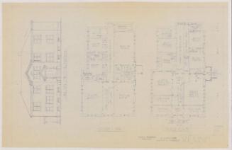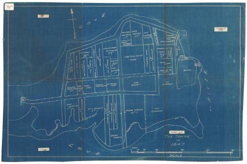
The Towne in 1647
DraftsmanDrawn by
Unknown
Date20th century
MediumBlueprint; cyanotype on paper
DimensionsPrimary Dimensions (image height x width): 16 1/2 x 25 1/4in. (41.9 x 64.1cm)
Sheet (height x width): 17 1/2 x 26in. (44.5 x 66cm)
Sheet (height x width): 17 1/2 x 26in. (44.5 x 66cm)
ClassificationsGraphics
Credit LineConnecticut Museum of Culture and History collection
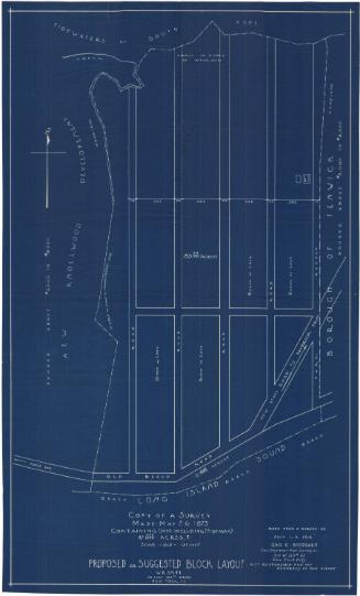
DescriptionBlueprint depicting the layout of Saybrook Point in 1647, including public spaces and plots of land with the owners' names. The public spaces include the meeting house yard, the green and the common. To the north is North Cove; the west, the Connecticut River; the south, South Cove; and the west, the gate. Along the southern edge of the peninsula is a marsh, and at the western tip is the fort.
Object number2012.312.21
MarkingsTop left, printed in black ink on sticker: "MAP BOX / #104"Top left, printed in black ink on paper taped to blueprint: "NORTH COVE"
Top right, printed in black ink on paper taped to blueprint: "CONNECTICUT RIVER"
Bottom left, printed in black ink on paper taped to blueprint: "SOUTH COVE"
Bottom right, printed in black ink on paper taped to blueprint: "SAYBROOK POINT"
Verso, center, stamped in blue ink: "CtHi"
InscribedRecto, bottom right, in white: "THE TOWNE / IN / 1647"
Verso, bottom left, handwritten in pencil: "MAP Box / 104"
Bottom left, handwritten in pencil: "Map Box #104"NotesCartographic note: Scale: 11 inches equals 160 rods
Classification Note: In terms of this project, "historical maps" refer to those made at a later date than the time period depicted.
Collections
- Maps and Charts: Finding Your Place in Connecticut History
On View
Not on view