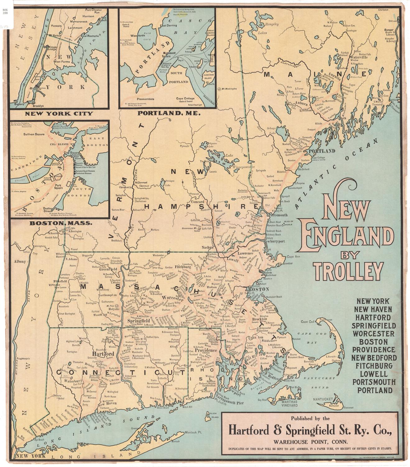
New England by Trolley
PrintmakerEngraved by
O. J. Peters & Son Co.
American, active 1905
PublisherPublished by the
Hartford & Springfield Street Railway Company
American, 1901 - 1926
Date1901-1926
MediumEngraving; black and colored printer's inks on paper, lined with paper
DimensionsPrimary Dimensions (image height x width): 23 1/8 x 20 1/4in. (58.7 x 51.4cm)
Sheet (height x width): 23 3/8 x 20 5/8in. (59.4 x 52.4cm)
Mount (height x width): 23 3/8 x 20 5/8in. (59.4 x 52.4cm)
Sheet (height x width): 23 3/8 x 20 5/8in. (59.4 x 52.4cm)
Mount (height x width): 23 3/8 x 20 5/8in. (59.4 x 52.4cm)
ClassificationsGraphics
Credit LineMuseum puchase
DescriptionMap of most of New England, from the southern portions of Vermont, New Hampshire and Maine to the north, the Atlantic Ocean to the east, Long Island and the Long Island Sound to the south, and New York State to the west. It shows the trolley routes in, around and between New York, New York; New Haven and Hartford, Connecticut; Springfield, Fitchburg, Worcester, Boston, Lowell, and New Bedford, Massachusetts; Providence, Rhode Island; Portsmouth, New Hampshire; and Portland, Maine. Open circles on the trolley lines presumably denote stops. In the top left corner are inset maps of New York City, Boston, and Portland, Maine. Natural features depicted include Mount Tom, rivers, lakes and islands. Elevation is conveyed through hachure marks.
Object number2004.140.0
MarkingsRecto, top left corner, printed in black ink on sticker: "BOX / 288"Verso, bottom left corner, stamped in ink: "Connecticut Historical Society / Library"InscribedRecto, right side, printed in peach and black ink: "NEW ENGLAND BY TROLLEY"
Right side, printed in black ink: "NEW YORK / NEW HAVEN / HARTFORD / SPRINGFIELD / WORCESTER / BOSTON / PROVIDENCE / NEW BEDFORD / FITCHBURG / LOWELL / PORTSMOUTH / PORTLAND"
Bottom right, rpinted in black ink: "Published by the / Hartford & Springfield St. Ry. Co., / WAREHOUSE POINT, CONN. / DUPLICATES OF THIS MAP WILL BE SENT TO ANY ADDRESS, IN A PAPER TUBE, ON RECEIPT OF FIFTEEN CENTS IN STAMPS."
Bottom right corner, printed in black ink: "C.J. PETERS & SON CO., ENGRS., BOSTON"
Verso, bottom left corner, handwritten in pencil: "MAPS / Box / 288 / 98654"NotesCartographic Note: No scale
Collections
- Maps and Charts: Finding Your Place in Connecticut History
On View
Not on view


Matthews-Northrup Company
1913