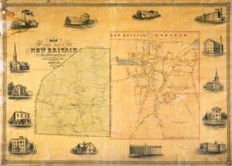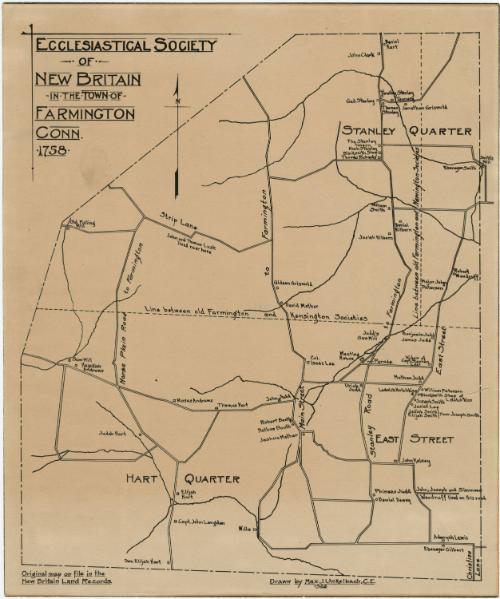
Map of the Ecclesiastical Society of New Britain in the Town of Farmington, Connecticut, 1758
DraftsmanDrawn by
Max J. Unkelbach
American, 1877 - 1938
Date1933
MediumLithography; black printer's ink on wove paper
DimensionsPrimary Dimensions (image height x width): 10 3/4 x 9 1/8in. (27.3 x 23.2cm)
Sheet (height x width): 11 3/4 x 9 7/8in. (29.8 x 25.1cm)
Sheet (height x width): 11 3/4 x 9 7/8in. (29.8 x 25.1cm)
ClassificationsGraphics
Credit LineGift of the Heirs of Morgan B. Brainard
DescriptionMap of a portion of Farmington, Connecticut, comprising the Ecclesiastical Society of New Britain. The map is divided into three parts, separated by broken solid lines marking the boundaries between the old Farmington and Newington Societies and the old Farmington and Kensington Societies. The top section is labeled "Stanley Quarter" and the bottom, "Hart Quarter." Local roads are shown and some of them are labeled. Squares mark the residences of property owners and are labeled with the owner's name.
Object number1960.93.22
MarkingsVerso, center, stamped in blue ink: "CtHi"InscribedRecto, top left, printed in black ink: "ECCLESIASTICAL SOCIETY / OF / NEW BRITAIN / IN THE TOWN OF / FARMINGTON / CONN. / 1758"Bottom left, printed in black ink: "Original map on file in the / New Britain Land Records"
Bottom, printed in black ink: "Drawn by Max. J. Unkelbach, C.E. / 1933"
Verso, top left, handwritten in pencil: "67092"
Top left, handwritten in blue ink: "Map / Box / #73"
Center, handwritten in pencil: "67092"
Bottom left, handwritten in pencil: "Map Box / 73"
Bottom right, handwritten in pencil: "67092"
Transcriptions:
The northeast portion of the map is labeled “Stanley Quarter” and the southwest portion is labeled “Hart Quarter”. The “Line between old Farmington and Kensington Societies” separate the northern and southern sections of the map. The “Line between old Farmington and Newington societies” separates the extreme northwest corner of the map to the east of Stanley Road.
Major roads include: Horse Plain Road, Strip Lane, Main Street, East Street, Christian Lane, Stanley Road
Property owners include: Hezekiah Andrews, Judah Hart, Elijah Hart, Capt. John Langdon, Moses Andrews, Thomas Hart, John Judd, Robert Booth, Nathan Booth, Joshua Mather, Col. Isaac Lee, John Lusk, Thomas Lusk, Gideon Griswold, David Mather, Urich Judd, Phineas Judd, Daniel Dewey, John Woodruff, Joseph Woodruff, Simmons Woodruff, Adonyah Lewis, Ebenezer Gilber, William Peterson, Joseph Smith, Josiah Lee, Jediah Smith, Elijah Smith, Ladwick Hotchkins, Nathan Judd, Widow of Capt. Stephen Lee, Benjamin Judd, James Judd, Major John Paterson, Robert Woodruff, Daniel Kilborn, William Smith, Ebenezer Smith, Noah Stanley, Thomas Richards, Jonathan Griswold, Thomas Stanley, Gad Stanley, Timothy Stanley, John Clark, Daniel Hart, Josiah Kilborn
Notable features include: Old Fulling Mill, saw mill, Meeting House, Parade, Blacksmith Shop of L. Hotchkiss, Judd’s Saw Mill, The Stanley Tavern, Smith’s Mill, Blacksmith Shop
NotesCartographical Scale: No scale
Collections
- Maps and Charts: Finding Your Place in Connecticut History
On View
Not on view