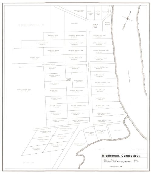
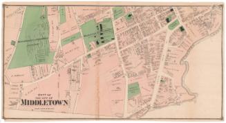
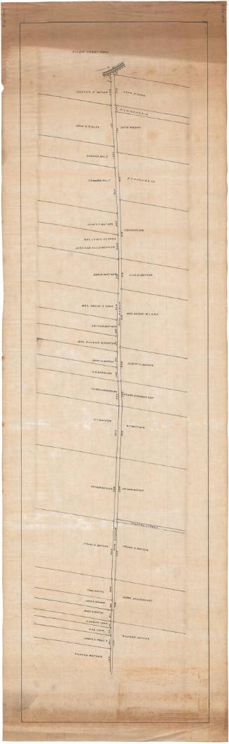
Middletown, Connecticut. Lower Houses: Homelots and Farmlots, 1650-1664
DraftsmanDrawn by
J. Paul Loether
American, born 1953
Date1981
MediumDrawing; pencil and dry transfer on paper
DimensionsPrimary Dimensions (image height x width): 22 1/4 x 19 1/2in. (56.5 x 49.5cm)
Sheet (height x width): 25 1/2 x 22 3/8in. (64.8 x 56.8cm)
Sheet (height x width): 25 1/2 x 22 3/8in. (64.8 x 56.8cm)
ClassificationsGraphics
Credit LineGift of J. Paul Loether
DescriptionMap of part of Middletown, Connecticut, extending from the Meeting House yard and burying ground to the north, the Connecticut River to the east, Pameacha Meadows to the south, and undivided land to the west. It depicts the farm and house lots along Main Street and Washington Street, as well as two unnamed local streets. Property owners are identified by name and the date of ownership, if available.
Object number1986.299.1
MarkingsRecto, top and bottom left corners, printed in black ink on stickers: "MAPS / Drawer / 79"Verso, bottom, handwritten in pencil on sticker: "1087"InscribedRecto, bottom, in dry transfer: "Middletown, Connecticut" / Lower Houses: / Homelots and Farmlots, 1650-1664 / J. Paul Loether - 1981 / SCALE: / 1" = 350'"
Property owners include:
Andrew Warner, William Smith, Nathaniel Bacon, Thomas Allen, William Marcum, George Hubbard, Nathaniel Brown, Thomas Wetmore, Samuel Stow, John Hall Sr., Henry Cole, William Cornell, William Cheney, Giles Hamline, William Goodwin, Giles Hamlin, Richard Hall, Samuel Hall, William Ward, Daniel Harris, Thomas Hopewell, John Martin, Alexander Bow, Thomas Miller, George Durant, Isacc Lane
Other notable landmarks include:
Pameacha Meadows, Burying Ground, Meeting House Yard, Town Lots
NotesCartographic Note: Scale: 1 inch equals 350 feet
Collections
- Maps and Charts: Finding Your Place in Connecticut History
On View
Not on view
Silvermine Production
1973