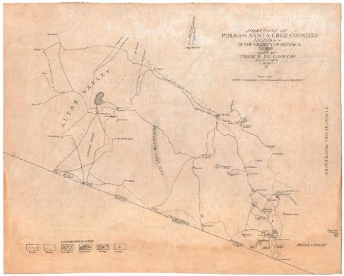
Portions of Pima and Santa Cruz Counties, Arizona
DraftsmanDrawn by
Unknown
Date1916
MediumDrawing; ink and pencil on linen
DimensionsPrimary Dimensions (image height x width): 23 x 28 1/2in. (58.4 x 72.4cm)
Sheet (height x width): 23 x 28 1/2in. (58.4 x 72.4cm)
Sheet (height x width): 23 x 28 1/2in. (58.4 x 72.4cm)
ClassificationsGraphics
Credit LineConnecticut Museum of Culture and History collection
DescriptionManuscript map of the physical features, mines, and camps in Pima and Santa Cruz counties, Arizona, extending from Ronstadt to the north, the Tumacacori Mountains to the west, the United States-Mexico border to the south, and Altar Valley to the west. The key, found in the lower left corner, explains the symbols for roads, trails, fresh marshes, lakes or ponds, villages, and corrals. Elevation is conveyed with hachure marks. At the top of the map, there are two north arrows, one marking magnetic north and the other marking true north.
Object number2012.312.101
InscribedRecto, top center, handwritten in black ink: "Mag. Defl. 12°"Top right, handwritten in black ink: "PORTIONS OF / PIMA AND SANTA CRUZ COUNTIES / ARIZONA / IN THE VICINITY OF ARIVACA / MADE BY TROOP B 5TH CONN. CAV. / SEPT - OCT / 1916"
Top right, handwritten in black ink: "Scale 1/63360"NotesCartographic Note: Scale: 1 inch equals 1 mile
Collections
- Maps and Charts: Finding Your Place in Connecticut History
On View
Not on view

1936-1944