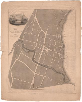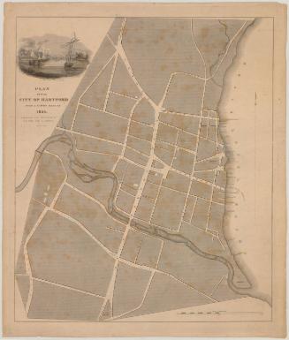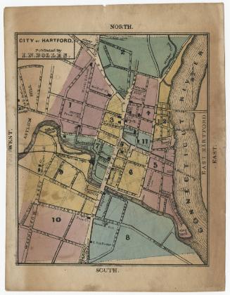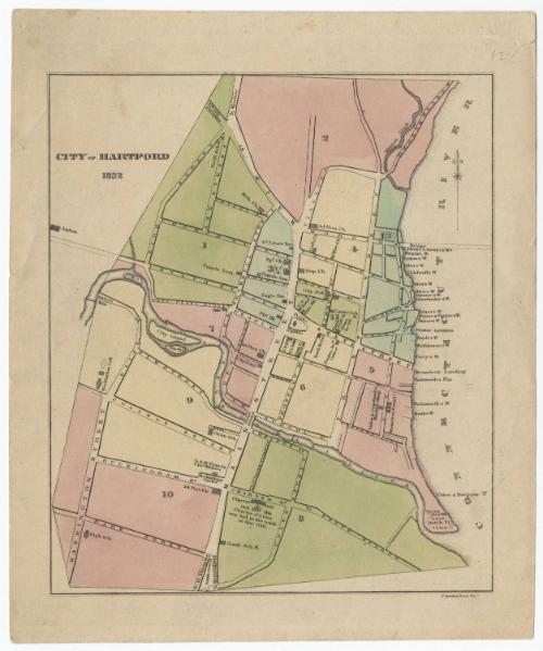
City of Hartford
PrintmakerEngraved by
Erastus B. Cunningham
American, active 1828 - 1845
Date1832
MediumEngraving; black printer's ink and watercolor on wove paper
DimensionsPrimary Dimensions (image height x width): 6 7/8 x 5 7/8in. (17.5 x 14.9cm)
Platemark (height only): 7 3/4in. (19.7cm)
Sheet (height x width): 8 3/8 x 6 7/8in. (21.3 x 17.5cm)
Platemark (height only): 7 3/4in. (19.7cm)
Sheet (height x width): 8 3/8 x 6 7/8in. (21.3 x 17.5cm)
ClassificationsGraphics
Credit LineConnecticut Museum of Culture and History collection
DescriptionMap of Hartford, Connecticut, divided into twelve wards. The city extends from Meadow Creek to the north, the Connecticut River to the east, the South School House to the south, and the asylum to the west. City streets, schools, churches, businesses and the site of the Charter Oak are labeled. At the far left side of the map, an unnamed asylum appears.
Object number2012.312.10
MarkingsVerso, center, stamped in blue ink: "CtHi"InscribedRecto, top right, handwritten in pencil: "12 C"Left side, printed in black ink: "CITY OF HARTFORD / 1832"
Bottom right, printed in black ink: "Cunningham Sc."
Verso, top left, handwritten in pencil: "Map / Box / #45.1"
Bottom left, handwritten in pencil: "MAP Box / 45.1"NotesCartographic Note: no scale
Collections
- Maps and Charts: Finding Your Place in Connecticut History
On View
Not on view