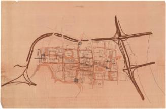
Windsor Street Project Disposition Map (Tentative)
ProducerProduced by
Hartford Redevelopment Agency
American
DateJune 1959
MediumPhotomechanical print; black ink on paper
DimensionsPrimary Dimensions (height x width): 26 1/4 x 41in. (66.7 x 104.1cm)
ClassificationsGraphics
Credit LineGift of the children of Richard and Georgette Koopman
DescriptionMap showing properties tentatively to be acquired and land dedicated for street use, utility easements, pedestrian right-of-way, and land acquired by the State of Connecticut (east-west highway). Project boundary encloses parts of Trumbull Street, Ely Street, Windsor Street, Market Street, and Pleasant Street.
Object number2007.24.675
Collections
- G. Fox & Co.
On View
Not on view
Erastus Worthington
about 1908