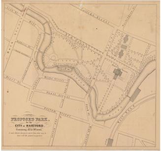
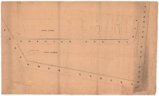
Map Showing Location of Proposed Canal
SurveyorSurveyed by
Seth E. Marsh
(American, about 1823 - 1878)
SurveyorSurveyed by
Henry W. Ayres
(American, 1848 - 1912)
Date1876
MediumDrawing; black, blue, and red ink on wove paper on fabric
DimensionsPrimary Dimensions (image height x width): 32 3/4 x 60 1/4in. (83.2 x 153cm)
Sheet (height x width): 36 x 63 3/4in. (91.4 x 161.9cm)
ClassificationsGraphics
Credit LineConnecticut Museum of Culture and History collection
Object number1970.27.15
DescriptionMap of a portion of West Hartford and Hartford with Reservoir No. 1 and the south branch of Trout Brook at the upper right and New Britain Road (New Britain Avenue) at the lower left. Property of Mrs. Flagg, E. Hawley, S. Seymour, M. Long, John Long, Geo. Woodruff, Sam. Colt, Scovill, Frank Woodruff, and Allonzo Collins lies along the route of the proposed canal. A house, a stock barn, chicken coop, ice house, and dairy are apparently on the Colt property. The canal also crosses Middle Road and South Road.
Label TextA drought in the early 1870s led to ever-increasing demands on Hartford's water system. New reservoirs continued to be built in West Hartford and new pipes continued to be laid, serving an ever larger area. The proposed canal shown in the map extends southwest from Reservoir No. 1 through West Hartford into Farmington. It was apparently intended to link with Reservoir No. 4. The map is one of the earliest maps in the Connecticut Historical Society collection to use contour intervals to depict elevation. The red lines, representing intervals of five feet, give a good idea of the hilly nature of the terrain.
NotesCartographic Note: One inch equals 200 feetStatus
Not on view