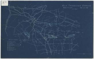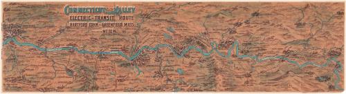
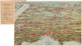
Connecticut Valley Electric Transit Route, Hartford, Connecticut to Greenfield, Massachusetts, Including Mt. Tom
DraftsmanDrawn by
Ernest A. Sherman
American, born 1870
PublisherPublished by
Thomas C. Perkins
American, born 1873
Date1905
MediumLithography; black and colored printer's inks on wove paper
DimensionsPrimary Dimensions (image height x width): 8 x 30 1/8in. (20.3 x 76.5cm)
Sheet (height x width): 8 1/4 x 30 1/2in. (21 x 77.5cm)
Sheet (height x width): 8 1/4 x 30 1/2in. (21 x 77.5cm)
ClassificationsGraphics
Credit LineConnecticut Museum of Culture and History collection
DescriptionPocket map, oriented east-west, of the trolley routes between Hartford, Connecticut and Greenfield, Massachusetts, along the Connecticut River. Towns and cities are depicted with clusters of buildings, including factory smokestacks. Rivers, lakes and ponds are in blue, and what are presumably the trolley lines are in white. Elevation is conveyed with hachure marks.
On the back are descriptions of the different towns along the railways, including dates of settlement, population, industry, and notable locations to visit. The Northampton Street Railway; Connecticut Valley Street Railway; Holyoke Street Railway; Springfield Street Railway; Woronoco Street Railway; Hartford and Springfield, East and West Side; and the Hartford Street Railway are the routes listed.
On the back are descriptions of the different towns along the railways, including dates of settlement, population, industry, and notable locations to visit. The Northampton Street Railway; Connecticut Valley Street Railway; Holyoke Street Railway; Springfield Street Railway; Woronoco Street Railway; Hartford and Springfield, East and West Side; and the Hartford Street Railway are the routes listed.
Object number2004.149.0
InscribedFront and back covers, in white ink on red background, outlined in black: "Connecticut Valley / Electric Transit Route"In white ink on red background, outlined in black: ""Take the Trolley""
Recto of map, top left, in clue and brown ink: "CONNECTICUT VALLEY / ELECTRIC TRANSIT ROUTE / HARTFORD, CONN. TO GREENFIELD, MASS. / INCLUDING MT. TOM"
Bottom right, printed in brown ink: "PUBLISHED BY T.C. PERKINS / HARTFORD, CONN. / 1905 / E.A. SHERMAN, DEL."NotesCartographic Note: No scale
Collections
- Maps and Charts: Finding Your Place in Connecticut History
On View
Not on view
Geo. H. Walker & Co.
1905
Traffic Department, New Haven, Connecticut
1915-1929