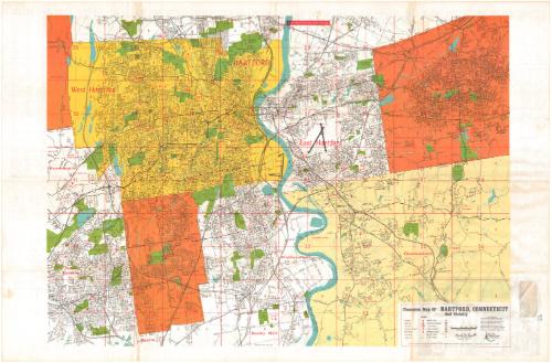
Champion Map of Hartford, Connecticut and vicinity
DraftsmanDrawn by
David J. Bennett
American, born 1942
PublisherPublished by the
Champion Map Corporation
American, 1959 - 1988
Date1972-1975
MediumOffset lithography; black and colored printer's inks on wove paper
DimensionsPrimary Dimensions (image height x width): 22 7/8 x 32in. (58.1 x 81.3cm)
Sheet (height x width): 25 x 38in. (63.5 x 96.5cm)
Sheet (height x width): 25 x 38in. (63.5 x 96.5cm)
ClassificationsGraphics
Credit LineMuseum purchase
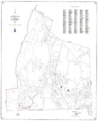
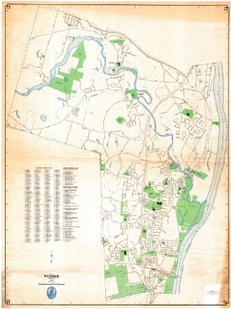
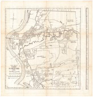
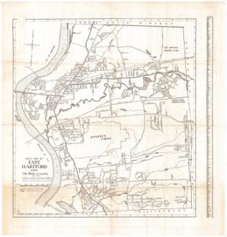
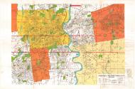
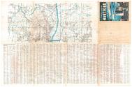
DescriptionMap of Hartford, Connecticut, and some of the surrounding towns, including West Hartford, East Hartford, Manchester, New Britain, Newington, Wethersfield, and Glastobury, with parts of Avon, Farmington, Berlin, Rock Hill. The map continues on the back of the sheet, with the towns of Simsbury, Bloomfield, Windsor, East Windsor and South Windsor depicted, with parts of Granby, East Granby, Windsor Locks, Ellington and Vernon. This portion of the map contains less detail than the main one. Both show local roads and highways, but there are more features on the primary map than on the secondary one. Parks, cemeteries and other open spaces are colored green, and schools, hospitals, colleges, points of interest, post offices and shopping centers are marked with red symbols. Water is colored blue. A street index appears on the back of the sheet.
Object number2000.182.1
MarkingsRecto, bottom right, stamped in blue ink: "CtHi"Verso, top right corner, printed in brown ink on silver sticker: "ARTHUR A. WATSON & CO. / INSURANCE AGENTS / 242 TRUMBULL STREET / HARTFORD, CONN. 06103 / 246-7451"
Top right, stamped in red ink: "CtHi"
InscribedRecto, bottom right, printed in black ink: "Champion Map of HARTFORD, CONNECTICUT / And Vicinity"
Bottom right, printed in black ink: "David J. Bennett / CHIEF CARTOGRAPHER"
Bottom right, printed in black ink: "COPYRIGHT / Champion Map / Corporation"
Bottom right, printed in black ink: "MAP PUBLISHERS FOR OVER 1,000 CITIES IN 33 STATES--ORDER FROM: CHAMPION MAP CORPORATION; P.O. BOX 17435, CHARLOTTE, N.C. 28211"
Bottom right, handwritten in pencil: "96089"
Verso, top right, printed in blue ink: "Copyright / Champion Map / Corporation / PO BOX 17435 CHARLOTTE N.C."
Top right, in white text on blue and black background: "CHAMPION FULLCOLOR MAP / HARTFORD / CONNECTICUT"
Top right, handwritten in pencil: "96089"
Top right, handwritten in pencil: "Maps / Shelf / 96089"NotesCartographic Note: Scale: 1 3/4 inch equals 4000 feet
Subject Terms
- Hartford (Conn.)
- West Hartford (Conn.)
- East Hartford (Conn.)
- Farmington (Conn.)
- New Britain (Conn.)
- Newington (Conn.)
- Wethersfield (Conn.)
- Glastonbury (Conn.)
- Manchester (Conn.)
- Windsor (Conn.)
- Windsor Locks (Conn.)
- Bloomfield (Conn.)
- East Granby (Conn.)
- East Windsor (Conn.)
- South Windsor (Conn.)
- Streets
- Highways
- Connecticut River
- Rivers
- Lithographs
- Regional Maps
- Road Maps
- Map Cataloging Project
- Hartford
- West Hartford
- East Hartford
- Newington
- Glastonbury
- Wethersfield
- New Britain
- Manchester
- Bloomfield
- Simsbury
- East Granby
- Windsor
- Windsor Locks
- East Windsor
- South Windsor
Collections
- Maps and Charts: Finding Your Place in Connecticut History
On View
Not on view